Geolocate

Shallotte topographic map

Click on the map to display elevation.

About this map

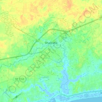
Name: Shallotte topographic map, elevation, terrain.

Location: Shallotte, Brunswick County, North Carolina, United States (33.91382 -78.46022 34.01290 -78.31393)

Average elevation: 10 m

Minimum elevation: -4 m

Maximum elevation: 25 m

Gear up for your next adventure:

Lightweight Backpacking Tent - Compact tent for efficient hiking trips
🔥Emergency Fire Starter - Reliable ignition source for all weather conditions
🕯️Camping Lantern - Illuminates your entire campsite with high-efficiency LEDs
🧦Crew Hiking Socks - Comfortable socks for long-distance hikes
🏕️Camping Hammock - Integrated protection for sleeping between trees

As an Amazon Associate, this site earns from qualifying purchases at no extra cost to you.