Geolocate

Lansing topographic map

Click on the map to display elevation.

Lansing

Lansing is a popular destination among retirees and tourists from Florida, as well as those from the lower elevations of the Carolinas and Georgia.

Wikipedia (CC-BY-SA 3.0)

About this map

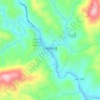
Name: Lansing topographic map, elevation, terrain.

Location: Lansing, Ashe County, North Carolina, United States (36.49279 -81.51646 36.50494 -81.50339)

Average elevation: 879 m

Minimum elevation: 801 m

Maximum elevation: 1,043 m

Gear up for your next adventure:

🧭GPS Handheld Device - Reliable GPS navigation for outdoor adventures
🎒Hiking Daypack - Lightweight and durable backpacks for day trips and excursions
🥾Trail Running Boots - Durable shoes designed for trail running
🔭Compact Binoculars - Lightweight optics for scouting trails and wildlife
🧰Survival Kit - Essential gear for emergencies in the wilderness

As an Amazon Associate, this site earns from qualifying purchases at no extra cost to you.