
Make a donation
Gear up for your next adventure:
As an Amazon Associate, this site earns from qualifying purchases at no extra cost to you.
Val d'Aran topographic map
Click on the map to display elevation.
Make a donation
Gear up for your next adventure:
As an Amazon Associate, this site earns from qualifying purchases at no extra cost to you.
About this map
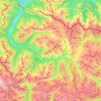
Name: Val d'Aran topographic map, elevation, terrain.
Location: Val d'Aran, Lleida, Catalonia, Spain (42.58915 0.63932 42.86152 1.03755)
Average elevation: 1,899 m
Minimum elevation: 544 m
Maximum elevation: 3,405 m
Make a donation
Gear up for your next adventure:
As an Amazon Associate, this site earns from qualifying purchases at no extra cost to you.
Other topographic maps
Click on a map to view its topography, its elevation and its terrain.
Make a donation
Gear up for your next adventure:
As an Amazon Associate, this site earns from qualifying purchases at no extra cost to you.
Corró d'Amunt
Spain > Catalonia > Vallès Oriental > les Franqueses del Vallès
Average elevation: 287 m
Make a donation
Gear up for your next adventure:
As an Amazon Associate, this site earns from qualifying purchases at no extra cost to you.
Make a donation
Gear up for your next adventure:
As an Amazon Associate, this site earns from qualifying purchases at no extra cost to you.
Make a donation
Gear up for your next adventure:
As an Amazon Associate, this site earns from qualifying purchases at no extra cost to you.
Sant Antoni de Calonge
Spain > Catalonia > Lower Empordà > Calonge i Sant Antoni
Average elevation: 20 m
Make a donation
Gear up for your next adventure:
As an Amazon Associate, this site earns from qualifying purchases at no extra cost to you.
Make a donation
Gear up for your next adventure:
As an Amazon Associate, this site earns from qualifying purchases at no extra cost to you.
Make a donation
Gear up for your next adventure:
As an Amazon Associate, this site earns from qualifying purchases at no extra cost to you.
les Casetes del Pujol
Spain > Catalonia > Alt Penedès > Castellví de la Marca > la Múnia
Average elevation: 185 m
Make a donation
Gear up for your next adventure:
As an Amazon Associate, this site earns from qualifying purchases at no extra cost to you.
Taüll
Spain > Catalonia > Alta Ribagorça > la Vall de Boí
Located at an altitude of 1,520 meters in the Sant Martí valley, a small valley in the Valley of Boí. The closest river is the Sant Martí river, Noguera de Tor affluent. A ravine splits the village in two districts: La Guinsa and Lo Barri. La Guinsa goes from the entrance of the village to the ravine, and…
Average elevation: 1,707 m
Make a donation
Gear up for your next adventure:
As an Amazon Associate, this site earns from qualifying purchases at no extra cost to you.
Make a donation
Gear up for your next adventure:
As an Amazon Associate, this site earns from qualifying purchases at no extra cost to you.
Parc Forestal de l'Ermita del Pla de Sant Joan
Spain > Catalonia > Baix Llobregat > la Palma de Cervelló > Urbanització Can Vidal
Average elevation: 127 m
Make a donation
Gear up for your next adventure:
As an Amazon Associate, this site earns from qualifying purchases at no extra cost to you.
Platja d'Aro
Spain > Catalonia > Lower Empordà > Castell d'Aro, Platja d'Aro i s'Agaró
Average elevation: 47 m
Make a donation
Gear up for your next adventure:
As an Amazon Associate, this site earns from qualifying purchases at no extra cost to you.
Taüll
Spain > Catalonia > Alta Ribagorça > la Vall de Boí
Located at an altitude of 1,520 meters in the Sant Martí valley, a small valley in the Valley of Boí. The closest river is the Sant Martí river, Noguera de Tor affluent. A ravine splits the village in two districts: La Guinsa and Lo Barri. La Guinsa goes from the entrance of the village to the ravine, and…
Average elevation: 1,707 m
Make a donation
Gear up for your next adventure:
As an Amazon Associate, this site earns from qualifying purchases at no extra cost to you.
les Agudes
Spain > Catalonia > Vallès Oriental > Montseny
Les Agudes is a mountain of Catalonia, Spain. It has an elevation of 1,706 metres (5,597 ft) above sea level. It is straddling the municipalities of Arbúcies in the Selva comarca and Fogars de Montclús and Montseny in the Vallès Oriental.
Average elevation: 1,288 m
Planell de Malgà
Spain > Catalonia > Pallars Sobirà > Baix Pallars > Gerri de la Sal > Bresca
Average elevation: 764 m
Make a donation
Gear up for your next adventure:
As an Amazon Associate, this site earns from qualifying purchases at no extra cost to you.
Bony de Serena
Spain > Catalonia > Alt Urgell > les Valls de Valira > Bordes de Jussà
Average elevation: 1,795 m
Make a donation
Gear up for your next adventure:
As an Amazon Associate, this site earns from qualifying purchases at no extra cost to you.
Make a donation
Gear up for your next adventure:
As an Amazon Associate, this site earns from qualifying purchases at no extra cost to you.
Make a donation
Gear up for your next adventure:
As an Amazon Associate, this site earns from qualifying purchases at no extra cost to you.
Piug de Miramar
Spain > Catalonia > Baix Llobregat > Sant Climent de Llobregat
Average elevation: 100 m
Make a donation
Gear up for your next adventure:
As an Amazon Associate, this site earns from qualifying purchases at no extra cost to you.
Make a donation
Gear up for your next adventure:
As an Amazon Associate, this site earns from qualifying purchases at no extra cost to you.
Escadarcs
Spain > Catalonia > Cerdanya > Fontanals de Cerdanya > el Vilar d'Urtx
Average elevation: 1,166 m
Parc dels Auditoris - El Parc del Fòrum
Spain > Catalonia > Barcelonès > Barcelona
Average elevation: 4 m
Make a donation
Gear up for your next adventure:
As an Amazon Associate, this site earns from qualifying purchases at no extra cost to you.
Make a donation
Gear up for your next adventure:
As an Amazon Associate, this site earns from qualifying purchases at no extra cost to you.
Make a donation
Gear up for your next adventure:
As an Amazon Associate, this site earns from qualifying purchases at no extra cost to you.
Sant Adrià de Besòs
Spain > Catalonia > Barcelonès > Sant Adrià de Besòs > Sant Adrià de Besòs
Average elevation: 35 m
Make a donation
Gear up for your next adventure:
As an Amazon Associate, this site earns from qualifying purchases at no extra cost to you.
Almoster
Spain > Catalonia > Baix Camp > Almoster
Its climate is dry Mediterranean, with low rainfall in the summer and occasionally heavy rainfall in spring and autumn. The driest month is July, with an average rainfall of only 15 mm, and September is usually the wettest, with an average of about 75 mm. The average annual precipitation barely reaches 500 mm.…
Average elevation: 289 m
Castell d'Aro
Spain > Catalonia > Lower Empordà > Castell d'Aro, Platja d'Aro i s'Agaró
Average elevation: 94 m
Make a donation
Gear up for your next adventure:
As an Amazon Associate, this site earns from qualifying purchases at no extra cost to you.
Puigverd de Lleida
Spain > Catalonia > Segrià > Puigverd de Lleida > Puigverd de Lleida
Average elevation: 217 m
Make a donation
Gear up for your next adventure:
As an Amazon Associate, this site earns from qualifying purchases at no extra cost to you.