Geolocate

Olot topographic map

Click on the map to display elevation.

About this map

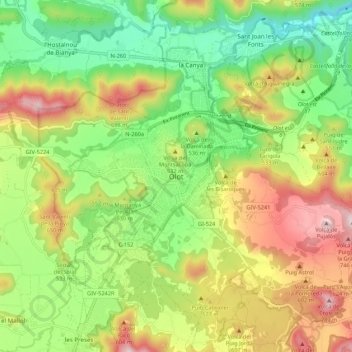
Name: Olot topographic map, elevation, terrain.

Location: Olot, Garrotxa, Girona, Catalonia, 17810, Spain (42.14222 2.44902 42.22222 2.52902)

Average elevation: 489 m

Minimum elevation: 267 m

Maximum elevation: 795 m

Gear up for your next adventure:

🧥Waterproof Hiking Jacket - Protect yourself from rain and wind while hiking
🔪Outdoor Multitool - Versatile tool for repairs and food prep in the wild
🦶Anti-Blister Balm - Prevents friction and hotspots during long ascents
🧰Survival Kit - Essential gear for emergencies in the wilderness
💡Compact LED Flashlight - Powerful and portable flashlight for outdoor use

As an Amazon Associate, this site earns from qualifying purchases at no extra cost to you.