Geolocate

Quarts topographic map

Click on the map to display elevation.

About this map

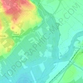
Name: Quarts topographic map, elevation, terrain.

Location: Quarts, Corbins, Segrià, Lleida, Catalonia, 25137, Spain (41.67046 0.68944 41.69046 0.70944)

Average elevation: 183 m

Minimum elevation: 161 m

Maximum elevation: 233 m

Gear up for your next adventure:

🥾Lightweight Hiking Boots - Boots for comfort and mobility on long hikes
🥾Approach Boots - Comfortable boots for hiking and climbing approaches
🧰Survival Kit - Essential gear for emergencies in the wilderness
💡Portable Camping Lamp - Rechargeable lamp for campsite lighting
🥾Waterproof Hiking Shoes - Durable shoes for wet and rugged trails

As an Amazon Associate, this site earns from qualifying purchases at no extra cost to you.