Geolocate

Baqueira topographic map

Click on the map to display elevation.

About this map

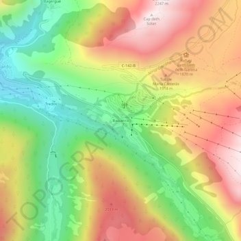
Name: Baqueira topographic map, elevation, terrain.

Location: Baqueira, Naut Aran, Val d'Aran, Catalonia, 25539, Spain (42.67927 0.91164 42.71927 0.95164)

Average elevation: 1,704 m

Minimum elevation: 1,250 m

Maximum elevation: 2,192 m

Other topographic maps

Click on a map to view its topography, its elevation and its terrain.

Bossòst

Spain > Catalonia > Val d'Aran

Average elevation: 1,396 m

Vielha e Mijaran

Spain > Catalonia > Val d'Aran

Average elevation: 1,880 m

Vilamòs

Spain > Catalonia > Val d'Aran

Average elevation: 1,419 m

Vielha e Mijaran

Spain > Catalonia > Val d'Aran

Average elevation: 1,880 m

Naut Aran

Spain > Catalonia > Val d'Aran

Average elevation: 2,049 m

Gear up for your next adventure:

🧢Sun Protection Cap - Breathable cap to protect from sun exposure
🧥Softshell Jacket - Windproof and breathable jacket for hiking
🧦Hiking Socks - Moisture-wicking and comfortable socks for long hikes
🧥Softshell Hiking Jacket - The perfect balance of wind protection and breathability
🔋Solar Power Bank - Keep your GPS and devices charged during long outdoor trips

As an Amazon Associate, this site earns from qualifying purchases at no extra cost to you.