
Gran Canaria topographic map
Interactive map
Click on the map to display elevation.
Gran Canaria
Gran Canaria is located in the Atlantic Ocean in a region known as Macaronesia about 150 kilometres (93 mi) off the northwestern coast of Africa and about 1,350 km (840 mi) from Europe. With an area of 1,560 km2 (602 sq. mi) and an altitude of 1,956 m (6,417 ft) at Morro de la Agujereada, Gran Canaria is the third largest island of the archipelago in both area and altitude. Gran Canaria is also the third most populated island in Spain.
About this map
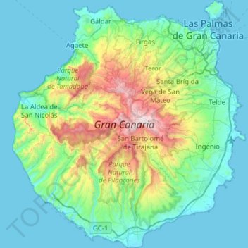
Name: Gran Canaria topographic map, elevation, terrain.
Location: Gran Canaria, Canary Islands, Spain (27.73458 -15.83465 28.18143 -15.35828)
Average elevation: 335 m
Minimum elevation: -1 m
Maximum elevation: 1,933 m
Other topographic maps
Click on a map to view its topography, its elevation and its terrain.
Las Vagas
Spain > Aragon > Cuencas Mineras > Martín del Río > La Rambla de Martín
Average elevation: 1,120 m
Arrutiegia
Spain > Autonomous Community of the Basque Country > Urola-Kosta > Aia
Average elevation: 223 m
Urbanització Cala Llonga
Spain > Balearic Islands > Ibiza > Santa Eulària des Riu
Average elevation: 39 m
Presa de Majarobledo
Spain > Extremadura > Las Hurdes > Casares de las Hurdes
Average elevation: 1,080 m
Donostia / San Sebastián
Spain > Autonomous Community of the Basque Country > Donostialdea > Donostia / San Sebastián
Average elevation: 134 m
Pollença
Spain > Balearic Islands > Serra de Tramuntana > Pollença > Pollença
Average elevation: 156 m
Madrid
Spain > Community of Madrid > Área metropolitana de Madrid y Corredor del Henares > Madrid
Average elevation: 650 m
Santiago de Compostela
Spain > Galicia > Santiago de Compostela
The cathedral borders the main plaza of the old and well-preserved city. According to medieval legend, the remains of the apostle James were brought to Galicia for burial; in 813, the light of a bright star guided a shepherd who was watching his flock at night to the burial site in Santiago de Compostela. This…
Average elevation: 248 m
Soil
Spain > Autonomous Community of the Basque Country > Montaña Alavesa/Arabako Mendialdea
Average elevation: 898 m
Cádiz
The Baluarte de la Candelaria (fortress or stronghold of Candlemas) is a military fortification. Taking advantage of a natural elevation of land, it was constructed in 1672 at the initiative of the governor, Diego Caballero de Illescas. Protected by a seaward-facing wall that had previously served as a…
Average elevation: 3 m
Urbanización Doña Pepa
Spain > Valencian Community > Rojales > Urbanización Doña Pepa
Average elevation: 24 m
Murcia
Spain > Region of Murcia > Region of Murcia > Murcia
Murcia is located near the center of a low-lying fertile plain known as the huerta (orchard or vineyard) of Murcia. The Segura River and its right-hand tributary, the Guadalentín, run through the area. The city has an elevation of 43 metres (141 ft) above sea level and its municipality covers approximately…
Average elevation: 169 m
El Port de la Selva
Spain > Catalonia > Upper Empordà > el Port de la Selva > El Port de la Selva
Average elevation: 76 m