Geolocate

Castroañe topographic map

Click on the map to display elevation.

About this map

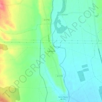
Name: Castroañe topographic map, elevation, terrain.

Location: Castroañe, Villaselán, León, Castile and León, 24344, Spain (42.52669 -5.07410 42.56669 -5.03410)

Average elevation: 873 m

Minimum elevation: 848 m

Maximum elevation: 931 m

Gear up for your next adventure:

🍽️Titanium Camping Spork - Ultralight and indestructible eating utensil
🥾Waterproof Hiking Shoes - Durable shoes for wet and rugged trails
🥾Mountain Trail Shoes - High-traction shoes for mountain trails
🗺️Topographic Maps - Detailed maps to explore trails, mountains, and wilderness areas
🧥Ultralight Puffy Jacket - Maximum warmth that packs down to the size of an orange

As an Amazon Associate, this site earns from qualifying purchases at no extra cost to you.