Geolocate

La Pared topographic map

Click on the map to display elevation.

About this map

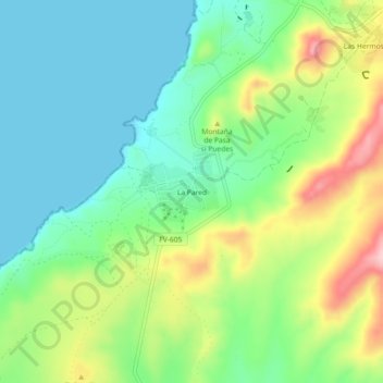
Name: La Pared topographic map, elevation, terrain.

Location: La Pared, Pájara, Las Palmas, Canary Islands, Spain (28.19213 -14.23442 28.23213 -14.19442)

Average elevation: 71 m

Minimum elevation: 0 m

Maximum elevation: 214 m

Gear up for your next adventure:

💡LED Camping Lantern - Illuminate your campsite with long-lasting lanterns
🧴Insect Repellent - Protect yourself from bugs during outdoor adventures
🥾All-Terrain Hiking Boots - Versatile boots for varied hiking conditions
🏕️Camping Hammock - Integrated protection for sleeping between trees
🛶Kayak Dry Bag - Waterproof storage for kayaking adventures

As an Amazon Associate, this site earns from qualifying purchases at no extra cost to you.