
Thank you for supporting this site ❤️
Make a donation
Make a donation
Gear up for your next adventure:
As an Amazon Associate, this site earns from qualifying purchases at no extra cost to you.
Pollença topographic map
Click on the map to display elevation.
Thank you for supporting this site ❤️
Make a donation
Make a donation
Gear up for your next adventure:
As an Amazon Associate, this site earns from qualifying purchases at no extra cost to you.
About this map
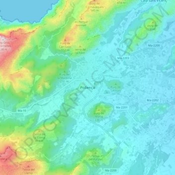
Name: Pollença topographic map, elevation, terrain.
Location: Pollença, Serra de Tramuntana, Balearic Islands, 07460, Spain (39.83921 2.97571 39.91921 3.05571)
Average elevation: 156 m
Minimum elevation: 0 m
Maximum elevation: 830 m
Thank you for supporting this site ❤️
Make a donation
Make a donation
Gear up for your next adventure:
As an Amazon Associate, this site earns from qualifying purchases at no extra cost to you.