Geolocate

Castillo de Alba topographic map

Click on the map to display elevation.

About this map

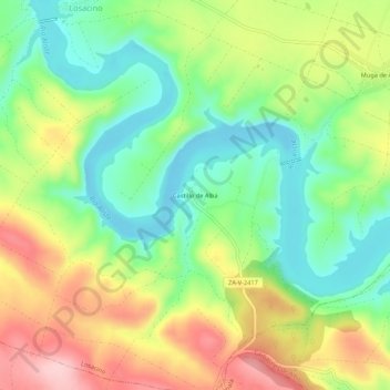
Name: Castillo de Alba topographic map, elevation, terrain.

Location: Castillo de Alba, Losacino, Zamora, Castile and León, Spain (41.64096 -6.08537 41.68096 -6.04537)

Average elevation: 745 m

Minimum elevation: 662 m

Maximum elevation: 861 m

Gear up for your next adventure:

🥾Waterproof Hiking Shoes - Durable shoes for wet and rugged trails
🧢Hiking Hat - Sun-protective and breathable hats for long treks
🦌Outdoor Trail Camera - Monitor wildlife activity near your favorite spots
🧳Compression Sacks - Maximize space in your backpack by shrinking gear
🧢Sun Hat - Wide-brim hat for sun protection

As an Amazon Associate, this site earns from qualifying purchases at no extra cost to you.