
Garachico topographic map
Interactive map
Click on the map to display elevation.
About this map
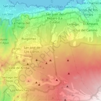
Name: Garachico topographic map, elevation, terrain.
Location: Garachico, Santa Cruz de Tenerife, Canary Islands, Spain (28.27185 -16.79710 28.38084 -16.70122)
Average elevation: 957 m
Minimum elevation: 0 m
Maximum elevation: 2,130 m
Other topographic maps
Click on a map to view its topography, its elevation and its terrain.
Las Vagas
Spain > Aragon > Cuencas Mineras > Martín del Río > La Rambla de Martín
Average elevation: 1,120 m
Arrutiegia
Spain > Autonomous Community of the Basque Country > Urola-Kosta > Aia
Average elevation: 223 m
Urbanització Cala Llonga
Spain > Balearic Islands > Ibiza > Santa Eulària des Riu
Average elevation: 39 m
Presa de Majarobledo
Spain > Extremadura > Las Hurdes > Casares de las Hurdes
Average elevation: 1,080 m
Donostia / San Sebastián
Spain > Autonomous Community of the Basque Country > Donostialdea > Donostia / San Sebastián
Average elevation: 134 m
Pollença
Spain > Balearic Islands > Serra de Tramuntana > Pollença > Pollença
Average elevation: 156 m
Madrid
Spain > Community of Madrid > Área metropolitana de Madrid y Corredor del Henares > Madrid
Average elevation: 650 m
Santiago de Compostela
Spain > Galicia > Santiago de Compostela
The cathedral borders the main plaza of the old and well-preserved city. According to medieval legend, the remains of the apostle James were brought to Galicia for burial; in 813, the light of a bright star guided a shepherd who was watching his flock at night to the burial site in Santiago de Compostela. This…
Average elevation: 248 m
Soil
Spain > Autonomous Community of the Basque Country > Montaña Alavesa/Arabako Mendialdea
Average elevation: 898 m
Cádiz
The Baluarte de la Candelaria (fortress or stronghold of Candlemas) is a military fortification. Taking advantage of a natural elevation of land, it was constructed in 1672 at the initiative of the governor, Diego Caballero de Illescas. Protected by a seaward-facing wall that had previously served as a…
Average elevation: 3 m
Urbanización Doña Pepa
Spain > Valencian Community > Rojales > Urbanización Doña Pepa
Average elevation: 24 m
Murcia
Spain > Region of Murcia > Region of Murcia > Murcia
Murcia is located near the center of a low-lying fertile plain known as the huerta (orchard or vineyard) of Murcia. The Segura River and its right-hand tributary, the Guadalentín, run through the area. The city has an elevation of 43 metres (141 ft) above sea level and its municipality covers approximately…
Average elevation: 169 m
El Port de la Selva
Spain > Catalonia > Upper Empordà > el Port de la Selva > El Port de la Selva
Average elevation: 76 m