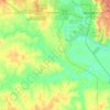
Williamson County topographic map
Click on the map to display elevation.
Williamson County
Williamson County occupies a distinctive Central Texas transition zone where the Balcones Escarpment and fault zone separate the rougher limestone uplands of the Edwards Plateau margin from the lower Blackland Prairie to the east. West of the Georgetown–Round Rock corridor, the terrain becomes more irregular and dissected, with shallow valleys, rocky slopes, thin limey soils, oak-juniper vegetation, and karst-influenced Hill Country features; eastward, the county opens into broader, gentler prairie terrain with dark clayey soils and a long agricultural character. The overall elevation pattern descends from the higher western and northwestern uplands toward the lower eastern plains, while waterways such as the San Gabriel River and Brushy Creek cut across the county and soften the relief with stream corridors, terraces, and alluvial lowlands. In physical character, Williamson County is therefore a meeting place of stony upland ridges, rolling escarpment country, and fertile prairie flats, giving it a varied but coherent topographic identity.
About this map
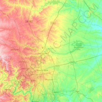
Name: Williamson County topographic map, elevation, terrain.
Location: Williamson County, Texas, United States (30.40281 -98.05005 30.90559 -97.15520)
Average elevation: 222 m
Minimum elevation: 110 m
Maximum elevation: 417 m
Other topographic maps
Click on a map to view its topography, its elevation and its terrain.
Enchanted Rock
United States > Texas > Llano County
Enchanted Rock is a pink granite mountain located in the Llano Uplift about 17 miles (27 km) north of Fredericksburg, Texas and 24 miles (39 km) south of Llano, Texas, United States. Enchanted Rock State Natural Area, which includes Enchanted Rock and surrounding land, spans the border between Gillespie and…
Average elevation: 453 m

Georgetown
United States > Texas > Georgetown
The city is located on the northeastern edge of Texas Hill Country. Portions of Georgetown are located on either side of the Balcones Escarpment, a fault line in which the areas roughly east of IH-35 are flat and characterized by having black, fertile soils of the Blackland Prairie, and the west side of the…
Average elevation: 219 m







Sierra Blanca
United States > Texas > Hudspeth County
Sierra Blanca is found in Far West Texas, a subdivision of West Texas, and is 4,520 feet (1,380 m) above sea level. The town is part of the Trans-Pecos region within the most mountainous and arid portion of Texas. The town is located in Hudspeth County, which is large and sparsely populated. Sierra Blanca…
Average elevation: 1,391 m


Belton
United States > Texas > Bell County > Belton > Belton
Belton is located 60 miles (97 km) north of Austin, 137 miles (220 km) south of Dallas, and 184 miles (296 km) west of Houston. It is near the center of Bell County at 31°3′32″N 97°27′48″W / 31.05889°N 97.46333°W / 31.05889; -97.46333 (31.058904, -97.463382). It is at the point where the…
Average elevation: 176 m



Roosevelt
United States > Texas > Lubbock County
Roosevelt is an unincorporated community in Lubbock County, Texas, United States. It sits at an elevation of 3136 feet (956 m). The community is part of the Lubbock Metropolitan Statistical Area. It mainly consists of Roosevelt High school. There is also a Baptist church here.
Average elevation: 957 m


Flint
United States > Texas > Smith County
Flint is an unincorporated community in southeastern Smith County, Texas, United States. It lies along FM 2493, south of the city of Tyler, the county seat of Smith County. Its elevation is 522 feet (159 m). Although Flint is unincorporated, it has a post office, with the ZIP code of 75762.
Average elevation: 146 m












Padre Island National Seashore
United States > Texas > Kenedy County > Corpus Christi
Average elevation: 5 m