Geolocate

Spicewood topographic map

Click on the map to display elevation.

About this map

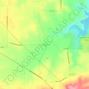
Name: Spicewood topographic map, elevation, terrain.

Location: Spicewood, Burnet County, Texas, United States (30.45592 -98.17664 30.49592 -98.13664)

Average elevation: 251 m

Minimum elevation: 199 m

Maximum elevation: 308 m

Other topographic maps

Click on a map to view its topography, its elevation and its terrain.

Cottonwood Shores

United States > Texas > Burnet County

Average elevation: 247 m

Inks Lake State Park

United States > Texas > Burnet County > Burnet

Conservation Pool Elevation usually stays around 888.22 ft. msl; however, this lake does fluctuate about 1 foot annually. Inks lake water clarity can be seen as clear to slightly stained mostly throughout the year. It tends to have higher turbidity during the rainy season due to excessive amounts of runoff.

Average elevation: 294 m

Marble Falls

United States > Texas > Burnet County

Average elevation: 278 m

Marble Falls

United States > Texas > Burnet County

Average elevation: 278 m

Burnet

United States > Texas > Burnet County

Average elevation: 404 m

Bertram

United States > Texas > Burnet County > Bertram

Average elevation: 372 m

Cottonwood Shores

United States > Texas > Burnet County

Average elevation: 247 m

Marble Falls

United States > Texas > Burnet County

Average elevation: 278 m

Gear up for your next adventure:

🥫Freeze-Dried Meals - Lightweight, high-calorie nutrition for multi-day treks
🧴Insect Repellent - Protect yourself from bugs during outdoor adventures
🥾Waterproof Hiking Boots - Boots keeping your feet dry in wet conditions
Bushcraft Tarp - Versatile emergency shelter or gear protection
🪑Insulated Seat Pad - Protect your seat from cold rocks and wet logs

As an Amazon Associate, this site earns from qualifying purchases at no extra cost to you.