Geolocate

Sedona topographic map

Click on the map to display elevation.

About this map

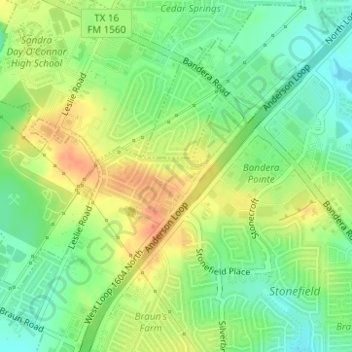
Name: Sedona topographic map, elevation, terrain.

Location: Sedona, San Antonio, Bexar County, Texas, United States (29.54893 -98.67550 29.55010 -98.67343)

Average elevation: 301 m

Minimum elevation: 281 m

Maximum elevation: 321 m

Other topographic maps

Click on a map to view its topography, its elevation and its terrain.

San Antonio

United States > Texas > Bexar County > San Antonio

Average elevation: 218 m

Theis Hill

United States > Texas > Bexar County > San Antonio

Average elevation: 258 m

Gear up for your next adventure:

💧Hydration Pack - Hands-free hydration system for long hikes
🧢Sun Protection Cap - Breathable cap to protect from sun exposure
🧴Sunscreen SPF - Broad-spectrum sunscreen for outdoor activities
🔋Solar Power Bank - Keep your GPS and devices charged during long outdoor trips
🥾Trekking Boots - Durable boots for long-distance trekking

As an Amazon Associate, this site earns from qualifying purchases at no extra cost to you.