Geolocate

Brookeland topographic map

Click on the map to display elevation.

About this map

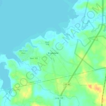
Name: Brookeland topographic map, elevation, terrain.

Location: Brookeland, Sabine County, Texas, United States (31.13269 -94.01352 31.17269 -93.97352)

Average elevation: 55 m

Minimum elevation: 47 m

Maximum elevation: 79 m

Other topographic maps

Click on a map to view its topography, its elevation and its terrain.

Hemphill

United States > Texas > Sabine County

Average elevation: 82 m

Gear up for your next adventure:

🥾Light Trekking Boots - Supportive boots for multi-day treks
🛌Down Sleeping Bag - Superior warmth-to-weight ratio for cold nights
🦯Trekking Poles - Reduced impact on joints for steep topographic climbs
🧴Bear Spray Holster - Quick-access carry for essential Canadian wilderness safety
🥾Durable Hiking Shoes - Long-lasting shoes for frequent hiking

As an Amazon Associate, this site earns from qualifying purchases at no extra cost to you.