Geolocate

Douglas County topographic map

Interactive map

Click on the map to display elevation.

About this map

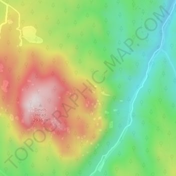
Name: Douglas County topographic map, elevation, terrain.

Location: Douglas County, Colorado, United States, The Greek Towers (39.26268 -105.09181 39.26298 -105.09152)

Average elevation: 2,631 m

Minimum elevation: 2,386 m

Maximum elevation: 2,951 m

Other topographic maps

Click on a map to view its topography, its elevation and its terrain.

Cripple Creek

United States > Colorado > Teller County

For many years, Cripple Creek's high valley, at an elevation of 9,494 feet (2,894 m), was considered no more important than a cattle pasture. Many prospectors avoided the area after the Mount Pisgah hoax, a mini gold rush caused by salting (adding gold to worthless rock).

Average elevation: 2,946 m

Thornton

United States > Colorado > Adams County

Average elevation: 1,601 m

Coal Creek

United States > Colorado > Fremont County

Average elevation: 1,671 m

Meeker

United States > Colorado > Rio Blanco County

According to the United States Census Bureau, the town has a total area of 2.9 square miles (7.5 km2), all of it land. The town is situated on the White River at an elevation of 6,250 feet above sea level.

Average elevation: 2,016 m

Lone Tree

United States > Colorado > Douglas County

Average elevation: 1,818 m

Greeley

United States > Colorado > Weld County

Greeley experiences a semi-arid climate (Köppen BSk). High temperatures are generally around 90–95 °F (32 °C) in the summer and 40-45 °F (4 °C) in the winter, although significant variation occurs. The hottest days generally occur around the third week of July and the coldest in January. Nighttime lows…

Average elevation: 1,448 m

Sheridan

United States > Colorado > Arapahoe County

Average elevation: 1,630 m

Littleton

United States > Colorado > Arapahoe County

Average elevation: 1,684 m

Steamboat Springs

United States > Colorado > Routt County

Average elevation: 2,228 m

Parker

United States > Colorado > Douglas County

Parker is located in northeastern Douglas County. Its northernmost border follows the Arapahoe County line, and the city of Aurora touches the town's northeast border. The center of Parker is 23 miles (37 km) southeast of downtown Denver. Castle Rock, the Douglas County seat, is 15 miles (24 km) to the…

Average elevation: 1,845 m

Superior

United States > Colorado > Boulder County

Average elevation: 1,689 m

Timnath

United States > Colorado > Larimer County

Average elevation: 1,493 m

Highlands Ranch

United States > Colorado > Douglas County

Average elevation: 1,758 m

Red Feather Lakes

United States > Colorado > Larimer County

Average elevation: 2,597 m

Aspen

United States > Colorado > Pitkin County

Aspen is the Home Rule City that is the county seat and the most populous municipality of Pitkin County, Colorado, United States. The city population was 7,004 at the 2020 United States Census. Aspen is in a remote area of the Rocky Mountains' Sawatch Range and Elk Mountains, along the Roaring Fork River at an…

Average elevation: 2,568 m

Costilla County

United States > Colorado

Average elevation: 2,654 m

Fountain

United States > Colorado > El Paso County

Average elevation: 1,724 m

Crested Butte

United States > Colorado > Gunnison County

At the 2020 United States Census, the town had a total area of 535 acres (2.166 km2), all of it land. Crested Butte lies at an elevation of 8,885 feet (2,708 m) above sea level.

Average elevation: 2,798 m

Larimer County

United States > Colorado

Average elevation: 2,363 m

Park County

United States > Colorado

Average elevation: 2,937 m

Pikes Peak

United States > Colorado > El Paso County

Soils on Pikes Peak above the timberline (approximately 12,000 ft or 3,700 m) are classified as Cirque land. Forests at lower altitudes mostly lie over the brown stony, sandy, loams of the Catamount loam or Ivywild loam series.

Average elevation: 3,902 m

Boulder County

United States > Colorado

Rocky Mountain National Park is in Boulder County, Larimer County, and Grand County. Longs Peak, the park's highest summit at 4,345 meters (14,255 feet) elevation, is located in Boulder County.

Average elevation: 2,308 m

Red Cone

United States > Colorado > Park County

Average elevation: 3,639 m

Telluride

United States > Colorado > San Miguel County

Telluride has an elevation of 8,750 feet (2,670 m) in an isolated spot in Southwest Colorado. From the west, Colorado Route 145 is the most common way into Telluride; two other passes enter the town, Imogene Pass and Black Bear Pass.

Average elevation: 3,125 m

Kit Carson County

United States > Colorado

Average elevation: 1,343 m

Montrose

United States > Colorado > Montrose County

Montrose features a semi-arid Continental climate zone. The town sits on high grasslands in the Uncompahgre Valley of Western Colorado. Snowfall occurs during the winter but is usually short-lived due to the high altitude and abundant sunshine.

Average elevation: 1,803 m

Teller County

United States > Colorado

Average elevation: 2,706 m

Silt

United States > Colorado > Garfield County

Average elevation: 1,695 m

Redlands

United States > Colorado > Mesa County

Average elevation: 1,607 m

Buffalo Mountain

United States > Colorado > Summit County

Average elevation: 3,428 m

Pagosa Springs

United States > Colorado > Archuleta County

Average elevation: 2,244 m

Portland

United States > Colorado > Ouray County

Average elevation: 2,478 m

Silverthorne

United States > Colorado > Summit County

Average elevation: 2,883 m

Lions Head

United States > Colorado > Park County

Average elevation: 2,653 m

Genesee

United States > Colorado > Jefferson County > Golden

Average elevation: 2,249 m

Frisco

United States > Colorado > Summit County

Average elevation: 2,835 m

Denver

United States > Colorado > Denver County > Denver

Average elevation: 1,684 m

Lake County

United States > Colorado

Lake County is a county located in the U.S. state of Colorado. As of the 2020 census, the population was 7,436. The county seat and the only municipality in the county is Leadville. The highest natural point in Colorado and the entire Rocky Mountains is the summit of Mount Elbert in Lake County at 14,440 feet…

Average elevation: 3,398 m

Winter Park

United States > Colorado > Grand County

Its elevation ranges from approximately 8,700 to 12,060 feet (2,650 to 3,680 m) above sea level, and is considered sub-alpine country. It is snow-covered for about six months a year. Although the town center is at about 9,000 feet (2,700 m) above sea level, Winter Park, using administrative boundaries as a…

Average elevation: 3,068 m

Windsor

United States > Colorado > Weld County

Some days in the winter and spring can be warm and extremely dry, with Chinook winds often raising temperatures to near 70 °F (21 °C) in January and February, and sometimes to near 90 °F (32 °C) in April. Windsor's elevation and low year-round humidity means that nighttime low temperatures are practically…

Average elevation: 1,485 m

Grizzly Ridge

United States > Colorado > Montrose County

Average elevation: 2,471 m

Crystal Mountain

United States > Colorado > Larimer County

Average elevation: 2,798 m

Centennial

United States > Colorado > Arapahoe County

Average elevation: 1,737 m

Estes Park

United States > Colorado > Larimer County

Estes Park sits at an elevation of 7,522 feet (2,293 m) on the front range of the Rocky Mountains at the eastern entrance of the Rocky Mountain National Park. Its north, south and east extremities border the Roosevelt National Forest. Lumpy Ridge lies immediately north of Estes Park.

Average elevation: 2,430 m

Elizabeth

United States > Colorado > Elbert County

Average elevation: 1,991 m

Keyhole

United States > Colorado > Delta County

Average elevation: 1,805 m

Tabernash

United States > Colorado > Grand County

On August 10, 1984, a Cessna L-19 Bird Dog (registration N4584A), piloted by James Jeb Caddell, 36, crashed in a forest near Tabernash. The aircraft was en route from Granby to Jeffco Airport, Colorado. The wreckage was found by backpackers three years later on August 23, 1987. A 6½ minute video shot from a…

Average elevation: 2,592 m

Lyons

United States > Colorado > Boulder County

Average elevation: 1,690 m

Twin Lakes

United States > Colorado > Adams County > Western Hills

Average elevation: 1,602 m

Eckert

United States > Colorado > Delta County

Average elevation: 1,691 m

Albion Lake

United States > Colorado > Boulder County

Average elevation: 3,497 m

Rio Grande County

United States > Colorado

Average elevation: 2,771 m

Hidden Lake

United States > Colorado > Boulder County

Average elevation: 2,679 m

Grizzly Peak

United States > Colorado > Chaffee County

Average elevation: 3,820 m

Saddle Mountain

United States > Colorado > Routt County

Average elevation: 2,034 m

Arvada

United States > Colorado > Jefferson County

Average elevation: 1,665 m

Fort Morgan

United States > Colorado > Morgan County

Fort Morgan is located at 40°15′12″N 103°47′57″W / 40.25333°N 103.79917°W / 40.25333; -103.79917 in Morgan County, Colorado at an elevation of 4,324 feet (1,318 m).

Average elevation: 1,315 m

Rollinsville

United States > Colorado > Gilpin County

Average elevation: 2,647 m

Manitou Springs

United States > Colorado > El Paso County

Average elevation: 2,144 m

Black Hawk

United States > Colorado > Gilpin County

Average elevation: 2,606 m

Divide

United States > Colorado > Teller County

Average elevation: 2,796 m

Florence

United States > Colorado > Fremont County > Florence

Average elevation: 1,601 m

Colorado Springs

United States > Colorado > El Paso County

At 6,035 feet (1,839 m) the city stands over 1 mile (1.6 km) above sea level. Colorado Springs is near the base of Pikes Peak, which rises 14,115 feet (4,302.31 m) above sea level on the eastern edge of the Southern Rocky Mountains. The city is the largest city north of Mexico above 6000 feet in elevation.

Average elevation: 2,229 m

Beulah

United States > Colorado > Pueblo County > Beulah

Average elevation: 2,013 m

Fort Carson

United States > Colorado > El Paso County > Fort Carson

Average elevation: 1,786 m

Gypsum

United States > Colorado > Eagle County

Average elevation: 2,174 m

Lakewood

United States > Colorado > Jefferson County

Lakewood is located at 39°42′17″N 105°04′53″W / 39.70472°N 105.08139°W / 39.70472; -105.08139 at an elevation of 5,518 feet (1,682 m). Located at the junction of U.S. Route 6 and Colorado State Highway 121 in central Colorado, the city lies immediately west of Denver and 62 miles (100 km)…

Average elevation: 1,690 m

Elbert County

United States > Colorado

Average elevation: 1,817 m

Baca County

United States > Colorado

Average elevation: 1,306 m

Huerfano County

United States > Colorado

Average elevation: 2,375 m

Cheyenne County

United States > Colorado

Average elevation: 1,330 m

Hells Gate

United States > Colorado > Eagle County

Average elevation: 2,174 m

Bedrock

United States > Colorado > Montrose County > Bedrock

Average elevation: 1,635 m

Buena Vista

United States > Colorado > Chaffee County > Buena Vista

Buena Vista is located in central Colorado roughly midway between Salida and Leadville in the Upper Arkansas River Valley at an elevation of 7,965 feet (2,428 m). The area between Buena Vista and Salida is often referred to as the Denver & Rio Grande, South Park & Pacific, and Colorado Midland railroads. Many…

Average elevation: 2,457 m

Vulcan Mountain

United States > Colorado > Chaffee County

Average elevation: 3,612 m

Jefferson County

United States > Colorado

Average elevation: 2,389 m

Buttes

United States > Colorado > El Paso County

Average elevation: 1,639 m

Englewood

United States > Colorado > Arapahoe County

Average elevation: 1,637 m

Boulder

United States > Colorado > Boulder County > Boulder

Boulder is located at the base of the foothills of the Rocky Mountains, at an elevation of 5,430 feet (1,655 m) above sea level. Boulder is 25 miles (40 km) northwest of the Colorado state capital of Denver. It is home of the main campus of the University of Colorado, the state's largest university.

Average elevation: 1,977 m

White River National Forest

United States > Colorado

There are ten peaks with an elevation higher than 14,000 ft (4,267m), colloquially known as 14ers in the forest.

Average elevation: 2,835 m

Central City

United States > Colorado > Gilpin County

Average elevation: 2,648 m

Grays Peak

United States > Colorado > Clear Creek County

Grays Peak is one of 53 fourteeners (mountains of over 14,000 feet (4,300 m) in elevation) in Colorado. Botanist Charles C. Parry made the first recorded ascent of the summit in 1861 and named the peak in honor of his botanist colleague Asa Gray. Gray did not see (and climb) the peak until 1872, eleven years…

Average elevation: 3,914 m

Torreys Peak

United States > Colorado > Clear Creek County

The third trail starts at Loveland Pass about 4.5 miles (7.2 km) to the northwest. To reach Loveland Pass, follow I-70 west from Denver 55 miles (89 km) to where US Route 6 breaks off and heads south. Follow the meandering Route 6 approximately seven miles to the trailhead at Loveland Pass, at an elevation of…

Average elevation: 3,855 m

Big Horn Dam

United States > Colorado > El Paso County

Average elevation: 3,697 m

Grizzly Peak

United States > Colorado > Clear Creek County

Average elevation: 3,719 m

Cañon City

United States > Colorado > Fremont County > Cañon City > Cañon City

The city's nickname, "the Climate Capital of Colorado", derives from the combination of unique geography and 5,300-foot (1,600 m) elevation protecting the city from harsh weather conditions. The average daily high temperature in January is 14 °F (7.8 °C) warmer in Cañon City than in Grand Junction, even…

Average elevation: 1,670 m

Oompah Tower

United States > Colorado > Mesa County

Average elevation: 1,708 m

Aurora

United States > Colorado > Adams County

Aurora's official elevation, posted on signs at the city limits, is 5,471 feet (1,668 m). However, the city spans a difference in elevation of nearly 1,000 feet (300 m). The lowest elevation of 5,285 feet (1,611 m) is found at the point where Sand Creek crosses the city limit in the northwest corner of the…

Average elevation: 1,691 m

Littleton

United States > Colorado > Arapahoe County > Littleton > Littleton

Littleton is located at 39°35′59″N 105°0′39″W / 39.59972°N 105.01083°W / 39.59972; -105.01083 (39.599691, −105.010929) at an elevation of 5,351 feet (1,631 m). Located in central Colorado at the junction of U.S. Route 85 and Colorado State Highway 470, the city is 9 miles (14 km) south…

Average elevation: 1,656 m

New Castle

United States > Colorado > Garfield County > New Castle

Average elevation: 1,810 m

Broomfield

United States > Colorado

The elevation of Broomfield is 5,348 feet (1,630 m). At the 2020 United States Census, Broomfield had a total area of 21,471 acres (86.890 km2), including 371 acres (1.503 km2) of water. It is the smallest county by area in Colorado, and the 5th smallest in the United States.

Average elevation: 1,609 m

Lions Head

United States > Colorado

Average elevation: 2,898 m

Cottonwood Peak

United States > Colorado

Average elevation: 3,716 m

Eagle County

United States > Colorado

The highest elevation in the county is the Mount of the Holy Cross which rises to 14,011 feet (4,271 m) above sea level. The lowest elevation is on the Colorado River at 6,128 feet (1,868 m).

Average elevation: 2,769 m

Chief Mountain

United States > Colorado

Average elevation: 3,367 m

The Flat Tops

United States > Colorado

Average elevation: 3,207 m