Geolocate

Redlands topographic map

Click on the map to display elevation.

About this map

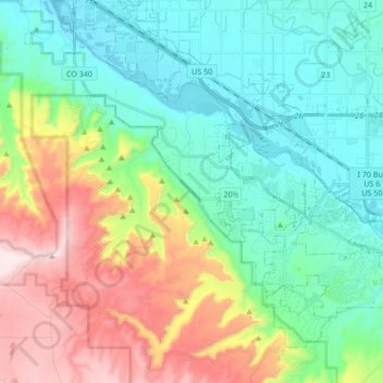
Name: Redlands topographic map, elevation, terrain.

Location: Redlands, Mesa County, Colorado, United States (39.03398 -108.73834 39.14098 -108.56855)

Average elevation: 1,607 m

Minimum elevation: 1,359 m

Maximum elevation: 2,172 m

Other topographic maps

Click on a map to view its topography, its elevation and its terrain.

Oompah Tower

United States > Colorado > Mesa County

Average elevation: 1,708 m

4 Road

United States > Colorado > Mesa County

Average elevation: 1,445 m

Gear up for your next adventure:

🛏️Camping Sleeping Mat - Comfortable mats for sleeping outdoors
🧴Waterproofing Spray - Restore the DWR coating on jackets and tents
🥾Trekking Poles - Adjustable trekking poles to reduce knee stress and improve stability
💧Collapsible Water Bottle - Space-saving water bottle for outdoor activities
🥾Hiking Leggings - Comfortable leggings for outdoor activities

As an Amazon Associate, this site earns from qualifying purchases at no extra cost to you.