Geolocate

Thornton topographic map

Click on the map to display elevation.

About this map

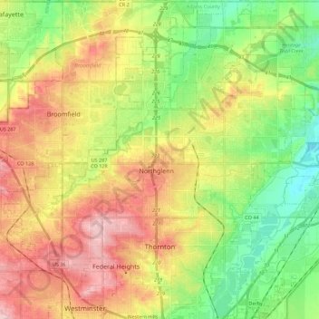
Name: Thornton topographic map, elevation, terrain.

Location: Thornton, Adams County, Colorado, United States (39.83101 -105.01553 40.00093 -104.87789)

Average elevation: 1,601 m

Minimum elevation: 1,520 m

Maximum elevation: 1,700 m

Other topographic maps

Click on a map to view its topography, its elevation and its terrain.

Twin Lakes

United States > Colorado > Adams County > Western Hills

Average elevation: 1,602 m

Gear up for your next adventure:

🩹Compact First Aid Kit - Pre-packed essentials for common trail injuries
🔦UV Flashlight - Detect minerals or specific insects in the dark
💡Solar Camping Lamp - Eco-friendly lighting for campsites
🔭Outdoor Binoculars - Lightweight binoculars for birdwatching and hiking
🧊Insulated Water Bottle - Keeps drinks cold in summer and prevents freezing in winter

As an Amazon Associate, this site earns from qualifying purchases at no extra cost to you.