

Colorado Springs topographic map
Click on the map to display elevation.
Colorado Springs
At 6,035 feet (1,839 m) the city stands over 1 mile (1.6 km) above sea level. Colorado Springs is near the base of Pikes Peak, which rises 14,115 feet (4,302.31 m) above sea level on the eastern edge of the Southern Rocky Mountains. The city is the largest city north of Mexico above 6000 feet in elevation.
About this map
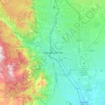
Name: Colorado Springs topographic map, elevation, terrain.
Average elevation: 2,229 m
Minimum elevation: 1,678 m
Maximum elevation: 3,853 m
Other topographic maps
Click on a map to view its topography, its elevation and its terrain.
Monument
United States > Colorado > El Paso County
Monument experiences a hemiboreal continental climate (Köppen Dfb) with warm, relatively rainy summers and cold, snowy winters. As with many areas of Colorado, Monument experiences a lot of sunshine with an average of 250 sunny days per year. The semi-arid climate keeps the dew point very low in Monument…
Average elevation: 2,160 m
Garden of the Gods Park
United States > Colorado > El Paso County > Colorado Springs
Average elevation: 1,982 m

Sleeping Giant
United States > Colorado > El Paso County > Colorado Springs
Average elevation: 1,971 m