Geolocate

Black Hawk topographic map

Click on the map to display elevation.

About this map

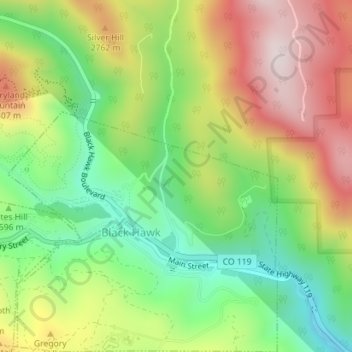
Name: Black Hawk topographic map, elevation, terrain.

Location: Black Hawk, Gilpin County, Colorado, United States (39.79192 -105.50565 39.81046 -105.47855)

Average elevation: 2,606 m

Minimum elevation: 2,409 m

Maximum elevation: 2,916 m

Other topographic maps

Click on a map to view its topography, its elevation and its terrain.

Rollinsville

United States > Colorado > Gilpin County

Average elevation: 2,647 m

Gear up for your next adventure:

🧥Waterproof Hiking Jacket - Protect yourself from rain and wind while hiking
🗺️Topographic Maps - Detailed maps to explore trails, mountains, and wilderness areas
🔭Compact Binoculars - Lightweight optics for scouting trails and wildlife
🧥Insulated Jacket - Keep warm in cold outdoor conditions
🛶Kayak Dry Bag - Waterproof storage for kayaking adventures

As an Amazon Associate, this site earns from qualifying purchases at no extra cost to you.