Geolocate

Frisco topographic map

Click on the map to display elevation.

About this map

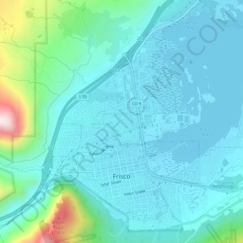
Name: Frisco topographic map, elevation, terrain.

Location: Frisco, Summit County, Colorado, United States (39.56718 -106.11404 39.59869 -106.06492)

Average elevation: 2,835 m

Minimum elevation: 2,748 m

Maximum elevation: 3,291 m

Other topographic maps

Click on a map to view its topography, its elevation and its terrain.

Silverthorne

United States > Colorado > Summit County

Average elevation: 2,883 m

Buffalo Mountain

United States > Colorado > Summit County

Average elevation: 3,428 m

Clinton Creek

United States > Colorado > Summit County

Average elevation: 3,788 m

Gear up for your next adventure:

🪑Insulated Seat Pad - Protect your seat from cold rocks and wet logs
🧢Outdoor Visor - Breathable visor for sunny hikes
🚲MTB Frame Bag - Carry tools and maps directly on your bicycle frame
🧴Bear Spray Holster - Quick-access carry for essential Canadian wilderness safety
🧦Hiking Socks - Moisture-wicking and comfortable socks for long hikes

As an Amazon Associate, this site earns from qualifying purchases at no extra cost to you.