Geolocate

Florence topographic map

Click on the map to display elevation.

About this map

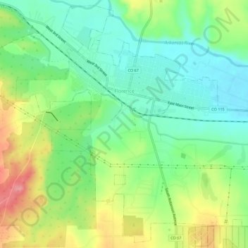
Name: Florence topographic map, elevation, terrain.

Location: Florence, Fremont County, Colorado, 81226, United States (38.36391 -105.14263 38.40513 -105.08776)

Average elevation: 1,601 m

Minimum elevation: 1,559 m

Maximum elevation: 1,670 m

Gear up for your next adventure:

🪜Heavy Duty Carabiners - Multi-use clips for securing gear to your backpack
🧊Portable Cooler - Keep food and drinks cold during outdoor adventures
🥾Approach Boots - Comfortable boots for hiking and climbing approaches
🧢Beanie Hat - Keep your head warm in cold weather
🧴First Aid Kit - Essential first aid supplies for outdoor emergencies

As an Amazon Associate, this site earns from qualifying purchases at no extra cost to you.