
Long Scraggy Peak topographic map
Interactive map
Click on the map to display elevation.
About this map
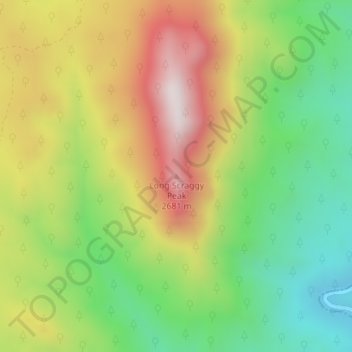
Name: Long Scraggy Peak topographic map, elevation, terrain.
Average elevation: 2,238 m
Minimum elevation: 1,909 m
Maximum elevation: 2,648 m
Other topographic maps
Click on a map to view its topography, its elevation and its terrain.
Golden
United States > Colorado > Jefferson County
Golden, Jefferson County, Colorado, United States
Average elevation: 1,936 m
Genesee
United States > Colorado > Jefferson County > Golden
Genesee, Golden, Jefferson County, Colorado, 80453, United States
Average elevation: 2,249 m
Morrison
United States > Colorado > Jefferson County
Morrison, Jefferson County, Colorado, 80465, United States
Average elevation: 1,892 m
Arvada
United States > Colorado > Jefferson County
Arvada, Jefferson County, Colorado, United States
Average elevation: 1,665 m
Lakewood
United States > Colorado > Jefferson County
Lakewood, Jefferson County, Colorado, United States
Average elevation: 1,690 m
Golden
United States > Colorado > Jefferson County > Golden
Golden, Jefferson County, Colorado, United States
Average elevation: 1,916 m