
Ise topographic map
Interactive map
Click on the map to display elevation.
About this map
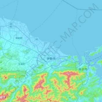
Name: Ise topographic map, elevation, terrain.
Location: Ise, Mie Prefecture, 516-0037, Japan (34.38472 136.63261 34.65348 136.82099)
Average elevation: 52 m
Minimum elevation: -5 m
Maximum elevation: 589 m
Ise is located on the northern half of Shima Peninsula in far eastern Mie Prefecture. The northern part of the city is flat land and faces Ise Bay on the Pacific Ocean. In the south, the land rises to form hills and mountains with an elevation of 100 to 500 meters. Most of the city is within the geographic limits of Ise-Shima National Park.
Other topographic maps
Click on a map to view its topography, its elevation and its terrain.
Mount Rishiri
Japan > Rishiri County > Rishirifuji
Mount Rishiri, Rishirifuji, Rishiri County, Soya Subprefecture, Hokkaido Prefecture, Japan
Average elevation: 1,098 m
Oyama
Oyama, Sunto County, Shizuoka Prefecture, Chubu Region, Japan
Average elevation: 737 m
Karuizawa
Karuizawa, Kitasaku County, Nagano Prefecture, Chubu Region, Japan
Average elevation: 1,117 m
Hinoemata
Hinoemata, Minamiaizu County, Fukushima Prefecture, Japan
Average elevation: 1,230 m
Kutchan
Kutchan, Abuta County, Shiribeshi Subprefecture, Hokkaido Prefecture, Japan
Average elevation: 374 m
Zama
Japan > Zama > Shindenjuku
Zama, Shindenjuku, Zama, Kanagawa Prefecture, 252-0027, Japan
Average elevation: 40 m
Odika
Odika, Kita-Matsuura County, Nagasaki Prefecture, Japan, Oshima Island
Average elevation: 3 m
Narusawa
Narusawa, Minamitsuru County, Yamanashi Prefecture, Chubu Region, Japan
Average elevation: 1,411 m
Sekigahara
Sekigahara, Fuwa County, Gifu Prefecture, 503-1592, Japan
Average elevation: 262 m
Shodoshima
Shodoshima, Shozu County, Kagawa Prefecture, 761-4411, Japan
Average elevation: 70 m