Geolocate

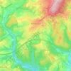
Buscht topographic map

Click on the map to display elevation.

About this map

Name: Buscht topographic map, elevation, terrain.

Location: Buscht, Utscheid, Südeifel, Eifelkreis Bitburg-Prüm, Rijnland-Palts, Duitsland (49.96938 6.33758 50.00938 6.37758)

Average elevation: 376 m

Minimum elevation: 285 m

Maximum elevation: 493 m

Other topographic maps

Click on a map to view its topography, its elevation and its terrain.

Gear up for your next adventure:

🔥Emergency Fire Starter - Reliable ignition source for all weather conditions
🧼Biodegradable Camp Soap - Environmentally friendly cleaning for gear and body
🥾Waterproof Trail Shoes - Shoes designed to handle wet terrain
🍽️Titanium Camping Spork - Ultralight and indestructible eating utensil
📷Outdoor Action Camera - Capture high-elevation views and rugged adventures

As an Amazon Associate, this site earns from qualifying purchases at no extra cost to you.