
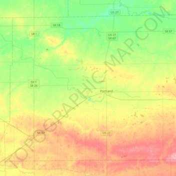
Jay County topographic map
Interactive map
Click on the map to display elevation.
About this map
Name: Jay County topographic map, elevation, terrain.
Location: Jay County, Indiana, United States (40.30732 -85.22054 40.57220 -84.80247)
Average elevation: 283 m
Minimum elevation: 240 m
Maximum elevation: 338 m
Other topographic maps
Click on a map to view its topography, its elevation and its terrain.
Carlson Lake
United States > Indiana > Porter County > Valparaiso
Carlson Lake, Valparaiso, Porter County, Indiana, United States
Average elevation: 250 m
Portage
United States > Indiana > Porter County
Portage, Porter County, Indiana, United States
Average elevation: 190 m
Oriole Lake
United States > Indiana > Perry County
Oriole Lake, Perry County, Indiana, United States
Average elevation: 211 m
French Lick
United States > Indiana > Orange County
French Lick, Orange County, Indiana, United States
Average elevation: 186 m
Danes
United States > Indiana > Cass County
Danes, Cass County, Indiana, United States
Average elevation: 203 m
Lawrence County
Lawrence County, Indiana, United States
Average elevation: 203 m
Franklin
United States > Indiana > Johnson County
Franklin, Johnson County, Indiana, 46131, United States
Average elevation: 230 m
Rockport
United States > Indiana > Spencer County
Rockport, Spencer County, Indiana, United States
Average elevation: 121 m
Michigan City
United States > Indiana > LaPorte County
Michigan City, LaPorte County, Indiana, United States
Average elevation: 188 m
Slough Creek
United States > Indiana > Jasper County
Slough Creek, Jasper County, Indiana, United States
Average elevation: 206 m
Bloomington
United States > Indiana > Monroe County
Bloomington, Monroe County, Indiana, United States
Average elevation: 241 m
Harrison County
Harrison County, Indiana, United States
Average elevation: 205 m
Galveston
United States > Indiana > Cass County
Galveston, Cass County, Indiana, United States
Average elevation: 246 m
Griffith
United States > Indiana > Lake County
Griffith, Lake County, Indiana, 46319, United States
Average elevation: 190 m
Kosciusko County
Kosciusko County, Indiana, United States
Average elevation: 262 m
Fish Creek
United States > Indiana > LaPorte County > Fish Lake
Fish Creek, Fish Lake, LaPorte County, Indiana, United States
Average elevation: 217 m
Madison
United States > Indiana > Madison
Madison, Jefferson County, Indiana, 47250, United States
Average elevation: 227 m
Jeffersonville
United States > Indiana > Clark County
Jeffersonville, Clark County, Indiana, 47130, United States
Average elevation: 150 m
Ripley County
United States > Indiana > Ripley County
Ripley County, Indiana, United States
Average elevation: 279 m
Merrillville
United States > Indiana > Lake County > Merrillville
Merrillville, Lake County, Indiana, 46410, United States
Average elevation: 204 m
Brownsburg
United States > Indiana > Hendricks County
Brownsburg, Hendricks County, Indiana, 46112, United States
Average elevation: 271 m
Fort Wayne
United States > Indiana > Allen County
Fort Wayne, Allen County, Indiana, United States
Average elevation: 246 m
Sullivan
United States > Indiana > Sullivan County > Sullivan > Sullivan
Sullivan, Sullivan County, Indiana, 47882, United States
Average elevation: 153 m
Grafton
United States > Indiana > Posey County
Grafton, Posey County, Indiana, United States
Average elevation: 120 m
Alert
United States > Indiana > Decatur County > Alert
Alert, Decatur County, Indiana, 47236, United States
Average elevation: 232 m
Muncie
United States > Indiana > Delaware County
Muncie, Delaware County, Indiana, United States
Average elevation: 291 m
Carmel
United States > Indiana > Hamilton County > Carmel
Carmel, Hamilton County, Indiana, United States
Average elevation: 253 m
Morningside
United States > Indiana > Delaware County > Muncie > Morningside
Morningside, Muncie, Delaware County, Indiana, 47303, United States
Average elevation: 291 m
Taggart
United States > Indiana > Brown County > Taggart
Taggart, Brown County, Indiana, United States
Average elevation: 237 m
West Lafayette
United States > Indiana > Tippecanoe County
West Lafayette, Tippecanoe County, Indiana, United States
Average elevation: 192 m
Terrace Bay
United States > Indiana > Carroll County > Terrace Bay
Terrace Bay, Carroll County, Indiana, United States
Average elevation: 205 m
Gary
United States > Indiana > Lake County > Gary
Gary, Lake County, Indiana, 46402, United States
Average elevation: 187 m
Indianapolis
United States > Indiana > Indianapolis
Indianapolis, Marion County, Indiana, 46204, United States
Average elevation: 241 m
Glen Eden
United States > Indiana > Steuben County > Glen Eden
Glen Eden, Steuben County, Indiana, 46703, United States
Average elevation: 310 m
Mill Race
United States > Indiana > Lawrence County > Spring Mill Village
Mill Race, Spring Mill Village, Lawrence County, Indiana, 47446, United States
Average elevation: 199 m
Dunn
United States > Indiana > Benton County > Dunn
Dunn, Benton County, Indiana, United States
Average elevation: 240 m
Mackey
United States > Indiana > Gibson County
Mackey, Gibson County, Indiana, United States
Average elevation: 131 m
Greenfield
United States > Indiana > Greenfield
Greenfield, Hancock County, Indiana, United States
Average elevation: 272 m
Indianapolis
United States > Indiana > Marion County
Indianapolis, Marion County, Indiana, United States
Average elevation: 241 m
Terre Haute
United States > Indiana > Terre Haute
Terre Haute, Vigo County, Indiana, United States
Average elevation: 159 m
Westchester
United States > Indiana > Fort Wayne > Westchester
Westchester, Fort Wayne, Allen County, Indiana, 48606, United States
Average elevation: 242 m
Crows Nest
United States > Indiana > Crows Nest
Crows Nest, Indiana, United States
Average elevation: 229 m