Geolocate

Gary topographic map

Click on the map to display elevation.

About this map

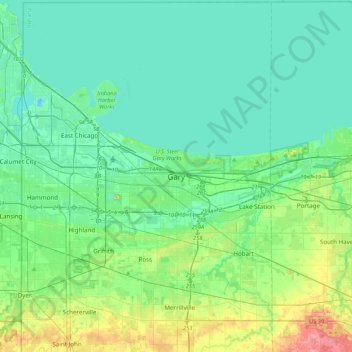
Name: Gary topographic map, elevation, terrain.

Location: Gary, Lake County, Indiana, 46402, United States (41.44213 -87.49714 41.76213 -87.17714)

Average elevation: 187 m

Minimum elevation: 170 m

Maximum elevation: 251 m

Gear up for your next adventure:

🧭GPS Tracker - Track your location in remote areas safely
🧊Portable Cooler - Keep food and drinks cold during outdoor adventures
💧Collapsible Water Bottle - Space-saving water bottle for outdoor activities
💧Filtered Water Bottle - Safe drinking water on the go
🩹Moleskin Blister Pads - Direct protection for painful foot pressure points

As an Amazon Associate, this site earns from qualifying purchases at no extra cost to you.