
Maple Creek No. 111 topographic map
Interactive map
Click on the map to display elevation.
About this map
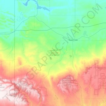
Name: Maple Creek No. 111 topographic map, elevation, terrain.
Location: Maple Creek No. 111, Saskatchewan, S0N 1N0, Canada (49.52355 -110.00511 50.13519 -109.25761)
Average elevation: 945 m
Minimum elevation: 708 m
Maximum elevation: 1,420 m
Saskatchewan trails, hiking, mountain biking, running and outdoor activities
Other topographic maps
Click on a map to view its topography, its elevation and its terrain.
Primrose Lake
Canada > Saskatchewan > Unorganized Division No. 18
Primrose Lake has a total surface area of 444 km2 (171 sq mi), 17.7 km2 (6.8 sq mi) of which is in Alberta, and an elevation of 559 metres (1,834 ft). It lies within muskeg and the boreal forest ecozone of Canada. There are several rivers and creeks that flow into the lake with Calder River on the northern…
Average elevation: 607 m
Jumping Lake
Canada > Saskatchewan > Division No. 15 > Invergordon No. 430 > Waitville
Average elevation: 500 m
Sipanok Channel
Canada > Saskatchewan > Division No. 18 > Unorganized Division No. 18
Average elevation: 277 m
McClean Lake
Canada > Saskatchewan > Division No. 18 > Unorganized Division No. 18
Average elevation: 440 m
Paradise Hill
Canada > Saskatchewan > Division No. 17 > Frenchman Butte No. 501
Average elevation: 647 m
Little Fishing Lake
Canada > Saskatchewan > Division No. 17 > Loon Lake No. 561
Average elevation: 617 m
Clearwater River
Canada > Saskatchewan > Division No. 18 > Unorganized Division No. 18
From Broach Lake at an elevation of 460 metres (1,510 ft) above sea level, the Clearwater drops about 150 metres (490 ft) to the confluence at Fort McMurray. Its waters eventually reach the Arctic Ocean via the Athabasca and Mackenzie Rivers. Tributaries of the Clearwater River include Descharme River and…
Average elevation: 450 m
Saskatoon
Canada > Saskatchewan > Saskatoon (city) > Saskatoon
Saskatoon lies on a long belt of rich, potassic chernozem in middle-southern Saskatchewan and is found in the aspen parkland biome. The lack of surrounding mountainous topography gives the city a relatively flat grid, though the city does sprawl over a few hills and into a few valleys. The lowest point in the…
Average elevation: 510 m