
Fukushima Prefecture topographic map
Interactive map
Click on the map to display elevation.
About this map
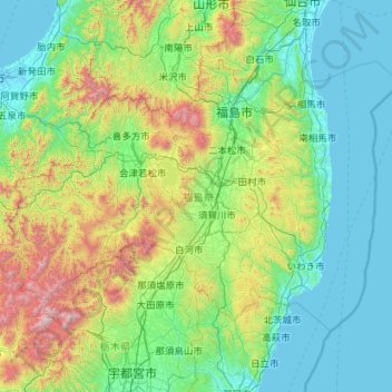
Name: Fukushima Prefecture topographic map, elevation, terrain.
Location: Fukushima Prefecture, Japan (36.74434 139.16474 37.98860 141.43766)
Average elevation: 402 m
Minimum elevation: -3 m
Maximum elevation: 2,554 m
Fukushima city is located in the Fukushima Basin's southwest area and nearby mountains. Located on the central eastern seaboard a part of the Pacifim rim. A region with high tectonic activity given its location where the Pacific and Eurasian continental plates collide - a part the Ring of Fire. " Aizuwakamatsu is located in the western part of Fukushima Prefecture, in the southeast part of Aizu basin. Mount Bandai is the highest mountain in the prefecture with an elevation of 1,819 m (5,968 ft). Mount Azuma-kofuji is an active stratovolcano that is 1,705 m (5,594 ft) tall with many onsen nearby. Lake Inawashiro is the 4th largest lake of Japan (103.3 km2 (39.9 sq mi)) in the center of the prefecture.
Other topographic maps
Click on a map to view its topography, its elevation and its terrain.
Oyama
Oyama, Sunto County, Shizuoka Prefecture, Chubu Region, Japan
Average elevation: 737 m
Karuizawa
Karuizawa, Kitasaku County, Nagano Prefecture, Chubu Region, Japan
Average elevation: 1,117 m
Hinoemata
Hinoemata, Minamiaizu County, Fukushima Prefecture, Japan
Average elevation: 1,230 m
Kutchan
Kutchan, Abuta County, Shiribeshi Subprefecture, Hokkaido Prefecture, Japan
Average elevation: 374 m
Zama
Japan > Zama > Shindenjuku
Zama, Shindenjuku, Zama, Kanagawa Prefecture, 252-0027, Japan
Average elevation: 40 m
Odika
Odika, Kita-Matsuura County, Nagasaki Prefecture, Japan, Oshima Island
Average elevation: 3 m
Narusawa
Narusawa, Minamitsuru County, Yamanashi Prefecture, Chubu Region, Japan
Average elevation: 1,411 m
Shodoshima
Shodoshima, Shozu County, Kagawa Prefecture, 761-4411, Japan
Average elevation: 70 m
Sekigahara
Sekigahara, Fuwa County, Gifu Prefecture, 503-1592, Japan
Average elevation: 262 m