
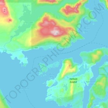
Jervis Inlet topographic map
Interactive map
Click on the map to display elevation.
About this map
Name: Jervis Inlet topographic map, elevation, terrain.
Average elevation: 173 m
Minimum elevation: -1 m
Maximum elevation: 1,282 m
British Columbia trails, hiking, mountain biking, running and outdoor activities
Other topographic maps
Click on a map to view its topography, its elevation and its terrain.
Kamloops
Canada > British Columbia > Thompson-Nicola Regional District > Kamloops
Average elevation: 875 m
Fairmont Hot Springs
Canada > British Columbia > Regional District of East Kootenay > Area F (Columbia Lake/Windermere Lake)
Average elevation: 920 m
Bowser
Canada > British Columbia > Regional District of Nanaimo > Area H (Lighthouse Country)
Average elevation: 52 m
Soprano Peak
Canada > British Columbia > Squamish-Lillooet Regional District > Area B (Cayoosh/Pavilion)
Average elevation: 2,137 m
Shawnigan Lake
Canada > British Columbia > Cowichan Valley Regional District > Area B (Shawnigan Lake)
Average elevation: 128 m
Nanoose Bay
Canada > British Columbia > Regional District of Nanaimo > Area E (Nanoose Bay)
Average elevation: 58 m
Lyall Point
Canada > British Columbia > Alberni-Clayoquot Regional District > Area C (Long Beach)
Average elevation: 1 m
Burnaby
Canada > British Columbia > Metro Vancouver Regional District > Burnaby
Burnaby occupies 98.60 square kilometres (38.07 sq mi) and is located at the geographic centre of the Metro Vancouver area and home to the Metro Vancouver regional government in Metrotown. Situated between the city of Vancouver on the west and Port Moody, Coquitlam, and New Westminster on the east, Burnaby is…
Average elevation: 144 m
Coquitlam
Canada > British Columbia > Metro Vancouver Regional District > Coquitlam
Southwest Coquitlam comprises the original core of the city, with Maillardville and Fraser River industrial sector giving way to the large residential areas of Austin Heights, colloquially referred to as "The Bump" due to its high and flat plateau topography. These older residences, with larger property…
Average elevation: 230 m
Barge Park
Canada > British Columbia > Metro Vancouver Regional District > White Rock
Average elevation: 53 m
Whistler
Canada > British Columbia > Squamish-Lillooet Regional District > Whistler Resort Municipality > Whistler
Average elevation: 996 m
Punchaw Lake
Canada > British Columbia > Regional District of Fraser-Fort George > Area C (Chilako River/Nechako)
Average elevation: 788 m
Riondel
Canada > British Columbia > Regional District of Central Kootenay > Area A (Wynndel/Crawford Bay/Riondel)
Average elevation: 675 m
Devils Thumb
Canada > British Columbia > Regional District of Kitimat-Stikine > Area D (Iskut/Big Raven)
Average elevation: 1,718 m
Ryder Lake
Canada > British Columbia > Fraser Valley Regional District > Chilliwack
Average elevation: 255 m
Misty Icefield
Canada > British Columbia > Fraser Valley Regional District > Area F (McConnell Creek/Hatzic Prairie)
Average elevation: 1,800 m
Langley Township
Canada > British Columbia > Metro Vancouver Regional District > Township of Langley > Langley Township
Average elevation: 37 m
Devils Thumb
Canada > British Columbia > Regional District of Kitimat-Stikine > Area D (Iskut/Big Raven)
Average elevation: 1,718 m
Glimpse Lake
Canada > British Columbia > Thompson-Nicola Regional District > Area M (Beautiful Nicola Valley - North)
Average elevation: 1,211 m
Grouse Mountain
Canada > British Columbia > Metro Vancouver Regional District
Grouse Mountain is one of the North Shore Mountains of the Pacific Ranges in the District Municipality of North Vancouver, British Columbia, Canada. With a maximum elevation of over 1,200 m (4,100 feet) at its peak, the mountain is the site of an alpine ski area, Grouse Mountain Resort, which overlooks Greater…
Average elevation: 968 m
Mount Dalton
Canada > British Columbia > Regional District of Kitimat-Stikine > Area F (Dease Lake)
Average elevation: 1,658 m
Blue Lake
Canada > British Columbia > Cariboo Regional District > Area A (Red Bluff/Quesnel South)
Average elevation: 781 m
Black Lake
Canada > British Columbia > Cariboo Regional District > Area C (Bowron Lake/Barlow Creek/Barkerville)
Average elevation: 1,705 m
Macdonald Island
Canada > British Columbia > Sunshine Coast Regional District > Area A (Egmont/Pender Harbour)
Average elevation: 230 m
Mayor Island
Canada > British Columbia > Regional District of Mount Waddington > Area A (Seymour Inlet/Knight Inlet)
Average elevation: 5 m
Burnaby Lake Regional Park
Canada > British Columbia > Metro Vancouver Regional District > Burnaby
Average elevation: 51 m
Cougar Creek Park
Canada > British Columbia > Metro Vancouver Regional District > Surrey
Average elevation: 86 m
Mount Sutton
Canada > British Columbia > Cowichan Valley Regional District > Area F (Cowichan Lake South / Skutz Falls)
Average elevation: 717 m
Thompson Glacier
Canada > British Columbia > Thompson-Nicola Regional District > Area B (Thompson Headwaters)
Average elevation: 2,313 m
Columbia River
Canada > British Columbia > Regional District of Central Kootenay > Castlegar
Average elevation: 598 m
Tumbling NE5
Canada > British Columbia > Regional District of East Kootenay > Area G (Forster Creek/Mount Assiniboine)
Average elevation: 2,146 m
Monroe Lake
Canada > British Columbia > Regional District of East Kootenay > Area C (Moyie/Bull River)
Average elevation: 1,105 m
Stanley Park
Canada > British Columbia > Metro Vancouver Regional District > Vancouver
Average elevation: 14 m
Coast Mountains
Canada > British Columbia > North Coast Regional District > Area A (North Skeena)
Average elevation: 334 m
Rockwall Peak
Canada > British Columbia > Columbia-Shuswap Regional District > Area A (Kicking Horse/Kinbasket Lake)
Average elevation: 2,431 m
San Juan Ridge
Canada > British Columbia > Capital Regional District > Juan de Fuca Electoral Area
Average elevation: 841 m
Eve River
Canada > British Columbia > Regional District of Mount Waddington > Area D (Nimpkish Valley/Cormorant Island)
Average elevation: 571 m
Tynehead Regional Park
Canada > British Columbia > Metro Vancouver Regional District > Surrey
Average elevation: 45 m
Mount Burgess
Canada > British Columbia > Columbia-Shuswap Regional District > Area A (Kicking Horse/Kinbasket Lake)
Average elevation: 1,938 m
The Table
Canada > British Columbia > Squamish-Lillooet Regional District > Area D (Elaho/Garibaldi)
Average elevation: 1,623 m
Mill Bay
Canada > British Columbia > Cowichan Valley Regional District > Area A (Mill Bay / Malahat)
Average elevation: 61 m
Whitehorn Mountain
Canada > British Columbia > Regional District of Fraser-Fort George > Area H (Robson Valley/Canoe)
Average elevation: 2,553 m
Stake Lake
Canada > British Columbia > Thompson-Nicola Regional District > Area J (Copper Desert Country)
Average elevation: 1,351 m
Kingsgate
Canada > British Columbia > Regional District of Central Kootenay > Area B (Goat River Valley)
Average elevation: 979 m
Mount Robson
Canada > British Columbia > Regional District of Fraser-Fort George > Area H (Robson Valley/Canoe)
The north face can be seen from Berg Lake, and reached by a 19 km (12 mi) hike. The lake is approximately 2 km long and lies at 1,646 m (5,400 ft) elevation. There are backcountry campgrounds at each end of the lake and a log shelter on its banks, named Hargreaves Shelter in honor of the Hargreaves family who…
Average elevation: 3,042 m
Blind Bay
Canada > British Columbia > Columbia-Shuswap Regional District > Area C (Blind Bay/Sorrento)
Average elevation: 414 m
Cecelia Creek Falls Park
Canada > British Columbia > Capital Regional District > Saanich
Average elevation: 36 m
Panorama Mountain Village
Canada > British Columbia > Regional District of East Kootenay > Area F (Columbia Lake/Windermere Lake)
Average elevation: 1,412 m
Rocky Mountains
Canada > British Columbia > Regional District of Fraser-Fort George > Area F (Willow River/Upper Fraser)
Average elevation: 1,252 m
The Copilot
Canada > British Columbia > Squamish-Lillooet Regional District > Area D (Elaho/Garibaldi)
Average elevation: 1,466 m
Shawnigan Lake
Canada > British Columbia > Cowichan Valley Regional District > Area B (Shawnigan Lake)
Average elevation: 128 m
Goldstream River
Canada > British Columbia > Capital Regional District > Juan de Fuca Electoral Area
Average elevation: 247 m
Secret Cove
Canada > British Columbia > Sunshine Coast Regional District > Area B (Halfmoon Bay)
Average elevation: 88 m
Oyster River
Canada > British Columbia > Comox Valley Regional District > Area C (Puntledge/Black Creek)
Average elevation: 973 m
Halfmoon Bay
Canada > British Columbia > Sunshine Coast Regional District > Area B (Halfmoon Bay)
Average elevation: 102 m
Beaverfoot Range
Canada > British Columbia > Columbia-Shuswap Regional District > Area A (Kicking Horse/Kinbasket Lake)
Average elevation: 2,123 m
Mt. Mulligan
Canada > British Columbia > Squamish-Lillooet Regional District > Area D (Elaho/Garibaldi)
Average elevation: 1,159 m
Seabird Rocks
Canada > British Columbia > Alberni-Clayoquot Regional District > Area A (Bamfield)
Average elevation: 0 m
Yale
Canada > British Columbia > Fraser Valley Regional District > Area B (South Fraser Canyon/Sunshine Valley)
Average elevation: 340 m
Larch Hills
Canada > British Columbia > Columbia-Shuswap Regional District > Area E (Eagle River Valley)
Average elevation: 1,225 m
Donald
Canada > British Columbia > Columbia-Shuswap Regional District > Area A (Kicking Horse/Kinbasket Lake)
Average elevation: 820 m
Wreck Beach
Canada > British Columbia > Metro Vancouver Regional District > Electoral Area A
Average elevation: 32 m
Ring Mountain
Canada > British Columbia > Squamish-Lillooet Regional District > Area D (Elaho/Garibaldi)
Average elevation: 1,816 m
Green Timbers Urban Forest
Canada > British Columbia > Metro Vancouver Regional District > Surrey
Average elevation: 100 m
Great Canyon
Canada > British Columbia > Cariboo Regional District > Area J (West Chilcotin)
Average elevation: 1,220 m
Rocky Mountains
Canada > British Columbia > Peace River Regional District > Area B (Finlay Valley/Beatton Valley)
Average elevation: 870 m
Pine Valley
Canada > British Columbia > Peace River Regional District > Area D (Kiskatinaw Valley)
Average elevation: 766 m
Rocky Mountains
Canada > British Columbia > Regional District of Fraser-Fort George > Area F (Willow River/Upper Fraser)
Average elevation: 1,421 m
View Lake
Canada > British Columbia > Alberni-Clayoquot Regional District > Area D (Sproat Lake)
Average elevation: 393 m
Mayne
Canada > British Columbia > Capital Regional District > Southern Gulf Islands Electoral Area
Average elevation: 52 m
Highest Peak
Canada > British Columbia > Sunshine Coast Regional District > Area F (West Howe Sound) > Plumper Cove
Average elevation: 42 m
Queen Elizabeth Park
Canada > British Columbia > Metro Vancouver Regional District > Vancouver
Average elevation: 81 m
The Black Tusk (True Summit)
Canada > British Columbia > Squamish-Lillooet Regional District > Area D (Elaho/Garibaldi)
Average elevation: 1,875 m
McLeod Lake
Canada > British Columbia > Regional District of Fraser-Fort George > Area G (Crooked River/Parsnip)
A point in the marshes on its southern shore of nearby Summit Lake marks the low point of the divide between the drainages of the Fraser and Peace Rivers, As such it is significant as the prominence col between all points south in the Rockies and beyond and their "parent" summits in northern BC and Alaska.…
Average elevation: 701 m
Manning Park
Canada > British Columbia > Regional District of Okanagan-Similkameen > Area H (Manning Park/Tulameen/Siwash)
Average elevation: 1,420 m
Mount Goodsir
Canada > British Columbia > Columbia-Shuswap Regional District > Area A (Kicking Horse/Kinbasket Lake)
Average elevation: 2,633 m
Mount Robson
Canada > British Columbia > Regional District of Fraser-Fort George > Area H (Robson Valley/Canoe)
The north face can be seen from Berg Lake, and reached by a 19 km (12 mi) hike. The lake is approximately 2 km long and lies at 1,646 m (5,400 ft) elevation. There are backcountry campgrounds at each end of the lake and a log shelter on its banks, named Hargreaves Shelter in honor of the Hargreaves family who…
Average elevation: 3,042 m
Annacis Island
Canada > British Columbia > Metro Vancouver Regional District > Delta
Average elevation: 16 m
Burnaby Mountain
Canada > British Columbia > Metro Vancouver Regional District > Burnaby
Due to its relatively high elevation, snow will often fall on the higher levels of Burnaby Mountain while rain falls in the surrounding cities. Tobogganing is a popular pastime at Centennial Park on winter days with snow.
Average elevation: 167 m
Mount Clemenceau
Canada > British Columbia > Columbia-Shuswap Regional District > Area A (Kicking Horse/Kinbasket Lake)
Average elevation: 2,928 m
Cascade Mountains
Canada > British Columbia > Regional District of Okanagan-Similkameen > Area G (Upper Similkameen/Hedley)
Average elevation: 1,979 m
Nelway
Canada > British Columbia > Regional District of Central Kootenay > Area G (Salmo Valley)
Average elevation: 924 m
Cascade Mountains
Canada > British Columbia > Regional District of Okanagan-Similkameen > Area B (Cawston/Lower Similkameen)
Average elevation: 1,207 m
Sandon
Canada > British Columbia > Regional District of Central Kootenay > Area H (The Slocan Valley)
Average elevation: 1,529 m
Whiskey Creek
Canada > British Columbia > Regional District of Nanaimo > Area F (Alberni Highway)
Average elevation: 126 m
Deep Creek
Canada > British Columbia > Regional District of Kitimat-Stikine > Area C (Butedale/Kitlope/Kitsumkalum)
Average elevation: 133 m
Essondale Islet
Canada > British Columbia > Metro Vancouver Regional District > Port Coquitlam
Average elevation: 12 m