Geolocate

Lake Fairy topographic map

Interactive map

Click on the map to display elevation.

About this map

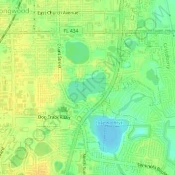
Name: Lake Fairy topographic map, elevation, terrain.

Location: Lake Fairy, Longwood, Seminole County, Florida, United States (28.68693 -81.33649 28.69170 -81.32964)

Average elevation: 24 m

Minimum elevation: 9 m

Maximum elevation: 35 m

Other topographic maps

Click on a map to view its topography, its elevation and its terrain.

Crystal River

United States > Florida > Citrus County

Average elevation: 4 m

Venice

United States > Florida > Sarasota County

Average elevation: 3 m

Nocatee

United States > Florida > Saint Johns County

Average elevation: 7 m

Boca Grande

United States > Florida > Lee County

Average elevation: 1 m

LaBelle

United States > Florida > Hendry County

Average elevation: 8 m

Yulee

United States > Florida > Nassau County > Yulee

Average elevation: 6 m

Glenwood

United States > Florida > Volusia County

Average elevation: 21 m

Plantation

United States > Florida > Broward County

Average elevation: 6 m

Marco Island

United States > Florida > Collier County

Parts of the island have some scenic, high elevations relative to the generally flat south Florida landscape. The island has a tropical climate; specifically a tropical wet and dry or savanna type (Aw under the Köppen system). It is known for its distinct wet and dry seasons, with most of the rainfall falling…

Average elevation: 2 m

Windermere

United States > Florida > Orange County

Average elevation: 34 m

San Antonio

United States > Florida > Pasco County

San Antonio has a rolling topography with elevations varying from a low of 110 feet on the western edge of the city to as high as 183 feet on a hill overlooking Lake Jovita on the eastern edge of town.

Average elevation: 44 m

Orange City

United States > Florida > Volusia County

Average elevation: 18 m

Old Town

United States > Florida > Dixie County

Average elevation: 7 m

Salt Springs

United States > Florida > Marion County

Average elevation: 9 m

Longboat Key

United States > Florida > Manatee County

Average elevation: 1 m

Zephyrhills

United States > Florida > Pasco County

Zephyrhills is known for its rolling topography, hence the name.

Average elevation: 32 m

Whitney

United States > Florida > Lake County

Average elevation: 25 m

Aventura

United States > Florida > Miami-Dade County > Aventura

In addition to its sea-level elevation, coastal location and position just north of the Tropic of Cancer, the area owes its warm, humid climate to the Gulf Stream, which moderates climate year-round. A typical summer day does not see temperatures below 75 °F (24 °C). Temperatures in the high 80s to low 90s…

Average elevation: 7 m

Odessa

United States > Florida > Pasco County > Odessa

Average elevation: 17 m

Lazy Lake

United States > Florida > Broward County

Average elevation: 6 m

Boden

United States > Florida > Volusia County

Average elevation: 7 m

Ave Maria

United States > Florida > Collier County

Ave Maria is 36 miles northeast of downtown Naples, Florida, and part of Collier County. The town's elevation is 18 feet. According to the United States Census Bureau, the city has a total area of 10.424sq mi (27.01km2).

Average elevation: 8 m

Lakeland

United States > Florida > Polk County

Average elevation: 44 m

Plummers

United States > Florida > Duval County > Jacksonville

Average elevation: 6 m

Parrish

United States > Florida > Manatee County

Average elevation: 12 m

Holiday

United States > Florida > Pasco County

Average elevation: 5 m

Fort Myers

United States > Florida > Lee County

Average elevation: 5 m

Loxahatchee Groves

United States > Florida > Palm Beach County

The area now known as Loxahatchee Groves was originally a portion of the 2,000,000 acres (8,100 km2) of land purchased by the Southern States Land and Timber Company in 1902. After the West Palm Beach Canal (C-51), which connected Lake Okeechobee at Canal Point to West Palm Beach, was completed in 1917, George…

Average elevation: 9 m

Apopka

United States > Florida > Orange County

Average elevation: 27 m

Plantation

United States > Florida > Sarasota County

Average elevation: 5 m

Hill 'n Dale

United States > Florida > Hernando County

Average elevation: 30 m

Orlando

United States > Florida > Orange County

Average elevation: 29 m

Palm Harbor

United States > Florida > Pinellas County

Average elevation: 9 m

Orange Park

United States > Florida > Clay County

Average elevation: 5 m

Pinecraft

United States > Florida > Sarasota County

Average elevation: 10 m

Woodmere

United States > Florida > Sarasota County > Venice

Average elevation: 5 m

Fivay Junction

United States > Florida > Pasco County

Average elevation: 21 m

Glen Saint Mary

United States > Florida > Baker County

Average elevation: 37 m

Royal Highlands

United States > Florida > Lake County

Average elevation: 30 m

Elfers

United States > Florida > Pasco County

Average elevation: 5 m

Gulfport

United States > Florida > Pinellas County

Average elevation: 7 m

Brandon

United States > Florida > Hillsborough County

Average elevation: 19 m

Cairo

United States > Florida > Hillsborough County > Tampa

Average elevation: 10 m

Riverview

United States > Florida > Hillsborough County

Average elevation: 13 m

Miami-Dade County

United States > Florida

Average elevation: 3 m

River Ridge

United States > Florida > Pasco County

Average elevation: 11 m

Monnette

United States > Florida > Hillsborough County > Tampa

Average elevation: 7 m

Nocatee

United States > Florida > DeSoto County

Average elevation: 11 m

Doral

United States > Florida > Miami-Dade County > Doral

Average elevation: 6 m

Port Richey

United States > Florida > Pasco County

Average elevation: 4 m

Innisbrook

United States > Florida > Pinellas County

Average elevation: 8 m

Lake Alfred

United States > Florida > Polk County

Average elevation: 41 m