Geolocate

Marco Island topographic map

Click on the map to display elevation.

Marco Island

Parts of the island have some scenic, high elevations relative to the generally flat south Florida landscape. The island has a tropical climate; specifically a tropical wet and dry or savanna type (Aw under the Köppen system). It is known for its distinct wet and dry seasons, with most of the rainfall falling between the months of June and October.

Wikipedia (CC-BY-SA 3.0)

About this map

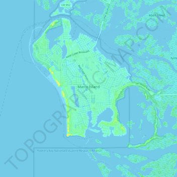
Name: Marco Island topographic map, elevation, terrain.

Location: Marco Island, Collier County, Florida, 34145, United States (25.89523 -81.75719 25.97530 -81.64822)

Average elevation: 2 m

Minimum elevation: -3 m

Maximum elevation: 24 m

Other topographic maps

Click on a map to view its topography, its elevation and its terrain.

Palm River

United States > Florida > Collier County

Average elevation: 6 m

Pelican Bay

United States > Florida > Collier County

Average elevation: 5 m

Lely Resort

United States > Florida > Collier County

Average elevation: 5 m

North Naples

United States > Florida > Collier County

Average elevation: 7 m

East Naples

United States > Florida > Collier County

Average elevation: 5 m

Pelican Bay

United States > Florida > Collier County

Average elevation: 5 m

East Naples

United States > Florida > Collier County

Average elevation: 5 m

Pelican Bay

United States > Florida > Collier County

Average elevation: 5 m

Naples Manor

United States > Florida > Collier County

Average elevation: 5 m

North Naples

United States > Florida > Collier County

Average elevation: 7 m

Pine Ridge

United States > Florida > Collier County

Average elevation: 7 m

Verona Walk

United States > Florida > Collier County

Average elevation: 5 m

Lely Resort

United States > Florida > Collier County

Average elevation: 5 m

Chokoloskee

United States > Florida > Collier County

Average elevation: 1 m

Vineyards

United States > Florida > Collier County > Naples

Average elevation: 6 m

East Naples

United States > Florida > Collier County

Average elevation: 5 m

Palm River

United States > Florida > Collier County

Average elevation: 6 m

Goodland

United States > Florida > Collier County > Goodland

Average elevation: 2 m

Orangetree

United States > Florida > Collier County

Average elevation: 6 m

Gear up for your next adventure:

🧢Beanie Hat - Keep your head warm in cold weather
🔥Emergency Fire Starter - Reliable ignition source for all weather conditions
🎒Fully Waterproof Backpack - Total protection for photography gear and electronics
👟Trail Running Shoes - Agile footwear for fast-paced topographic exploration
🧭GPS Handheld Device - Reliable GPS navigation for outdoor adventures

As an Amazon Associate, this site earns from qualifying purchases at no extra cost to you.