
Takasaki topographic map
Interactive map
Click on the map to display elevation.
About this map
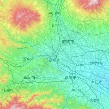
Name: Takasaki topographic map, elevation, terrain.
Location: Takasaki, Gunma Prefecture, Japan (36.19859 138.64251 36.48347 139.12966)
Average elevation: 331 m
Minimum elevation: 36 m
Maximum elevation: 1,555 m
Takasaki is located in the southwestern part of Gunma Prefecture in the flat northwestern part of the Kantō Plain. The city is located approximately 90 to 100 kilometers from central Tokyo . Mount Akagi, Mount Haruna and Mount Myogi can be seen from the city, and the southern slopes of Mount Haruna are within the city limits. The Tone River, Karasu River and Usui River flow through the city. Although Takasaki is located over 100 kilometers from the coast, much of the city is low-lying, and the elevation of the city hall and central city area is only 97 meters above sea level. The land rises to the northern and western parts of the city to a maximum elevation of 1690 meters.
Other topographic maps
Click on a map to view its topography, its elevation and its terrain.
Oyama
Oyama, Sunto County, Shizuoka Prefecture, Chubu Region, Japan
Average elevation: 737 m
Karuizawa
Karuizawa, Kitasaku County, Nagano Prefecture, Chubu Region, Japan
Average elevation: 1,117 m
Hinoemata
Hinoemata, Minamiaizu County, Fukushima Prefecture, Japan
Average elevation: 1,230 m
Kutchan
Kutchan, Abuta County, Shiribeshi Subprefecture, Hokkaido Prefecture, Japan
Average elevation: 374 m
Zama
Japan > Zama > Shindenjuku
Zama, Shindenjuku, Zama, Kanagawa Prefecture, 252-0027, Japan
Average elevation: 40 m
Odika
Odika, Kita-Matsuura County, Nagasaki Prefecture, Japan, Oshima Island
Average elevation: 3 m
Narusawa
Narusawa, Minamitsuru County, Yamanashi Prefecture, Chubu Region, Japan
Average elevation: 1,411 m
Shodoshima
Shodoshima, Shozu County, Kagawa Prefecture, 761-4411, Japan
Average elevation: 70 m
Sekigahara
Sekigahara, Fuwa County, Gifu Prefecture, 503-1592, Japan
Average elevation: 262 m