
Fujisawa topographic map
Interactive map
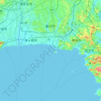
Click on the map to display elevation.
About this map
Name: Fujisawa topographic map, elevation, terrain.
Location: Fujisawa, Kanagawa Prefecture, Japan (35.17795 139.39398 35.42909 139.51685)
Average elevation: 17 m
Minimum elevation: -3 m
Maximum elevation: 205 m
Fujisawa has three major topographical features: the island of Enoshima to the south connected to the Katase shoreline area by a road bridge, and two rivers, the Hikiji and the Sakai, which run north-south. The Hikiji can be traced from an area designated as a nature reserve park in the city of Yamato and flows directly along the boundary of the joint US Navy and Japan Maritime Self-Defense Force Atsugi Naval Air Base and the United States Army Camp Zama. The Sakai runs directly from the mountains between Machida and Hachiōji, and for quite some distance forms the border between the Tokyo Metropolitan Area and Kanagawa Prefecture. From Machida city centre, the river can be directly followed by a foot and cycle path to Fujisawa city centre, a distance of approximately 35 km (22 mi). Another cycle path runs along the Shonan Coastal path, from the Sagami River, in Hiratsuka, to Enoshima Bridge in Fujisawa.
Other topographic maps
Click on a map to view its topography, its elevation and its terrain.
Oyama
Oyama, Sunto County, Shizuoka Prefecture, Chubu Region, Japan
Average elevation: 737 m
Karuizawa
Karuizawa, Kitasaku County, Nagano Prefecture, Chubu Region, Japan
Average elevation: 1,117 m
Hinoemata
Hinoemata, Minamiaizu County, Fukushima Prefecture, Japan
Average elevation: 1,230 m
Kutchan
Kutchan, Abuta County, Shiribeshi Subprefecture, Hokkaido Prefecture, Japan
Average elevation: 374 m
Zama
Japan > Zama > Shindenjuku
Zama, Shindenjuku, Zama, Kanagawa Prefecture, 252-0027, Japan
Average elevation: 40 m
Odika
Odika, Kita-Matsuura County, Nagasaki Prefecture, Japan, Oshima Island
Average elevation: 3 m
Narusawa
Narusawa, Minamitsuru County, Yamanashi Prefecture, Chubu Region, Japan
Average elevation: 1,411 m
Shodoshima
Shodoshima, Shozu County, Kagawa Prefecture, 761-4411, Japan
Average elevation: 70 m
Sekigahara
Sekigahara, Fuwa County, Gifu Prefecture, 503-1592, Japan
Average elevation: 262 m