
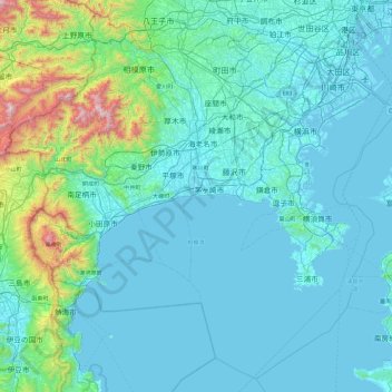
Kanagawa Prefecture topographic map
Interactive map
Click on the map to display elevation.
About this map
Name: Kanagawa Prefecture topographic map, elevation, terrain.
Location: Kanagawa Prefecture, Japan (34.95717 138.91577 35.67290 139.85775)
Average elevation: 170 m
Minimum elevation: -4 m
Maximum elevation: 1,639 m
Topographically, the prefecture consists of three distinct areas. The mountainous western region features the Tanzawa Mountain Range and Hakone Volcano. The hilly eastern region is characterized by the Tama Hills and Miura Peninsula. The central region, which surrounds the Tama Hills and Miura Peninsula, consists of flat stream terraces and low lands around major rivers including the Sagami River, Sakai River, Tsurumi River, and Tama River.
Other topographic maps
Click on a map to view its topography, its elevation and its terrain.
Oyama
Oyama, Sunto County, Shizuoka Prefecture, Chubu Region, Japan
Average elevation: 737 m
Karuizawa
Karuizawa, Kitasaku County, Nagano Prefecture, Chubu Region, Japan
Average elevation: 1,117 m
Hinoemata
Hinoemata, Minamiaizu County, Fukushima Prefecture, Japan
Average elevation: 1,230 m
Kutchan
Kutchan, Abuta County, Shiribeshi Subprefecture, Hokkaido Prefecture, Japan
Average elevation: 374 m
Zama
Japan > Zama > Shindenjuku
Zama, Shindenjuku, Zama, Kanagawa Prefecture, 252-0027, Japan
Average elevation: 40 m
Odika
Odika, Kita-Matsuura County, Nagasaki Prefecture, Japan, Oshima Island
Average elevation: 3 m
Narusawa
Narusawa, Minamitsuru County, Yamanashi Prefecture, Chubu Region, Japan
Average elevation: 1,411 m
Shodoshima
Shodoshima, Shozu County, Kagawa Prefecture, 761-4411, Japan
Average elevation: 70 m
Sekigahara
Sekigahara, Fuwa County, Gifu Prefecture, 503-1592, Japan
Average elevation: 262 m