
Town of Cedarburg topographic map
Interactive map
Click on the map to display elevation.
About this map
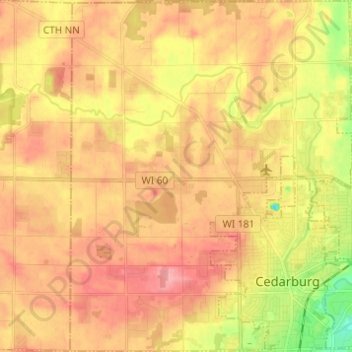
Name: Town of Cedarburg topographic map, elevation, terrain.
Location: Town of Cedarburg, Ozaukee County, Wisconsin, United States (43.27876 -88.06331 43.36769 -87.96422)
Average elevation: 261 m
Minimum elevation: 202 m
Maximum elevation: 300 m
Other topographic maps
Click on a map to view its topography, its elevation and its terrain.
Elm Grove
United States > Wisconsin > Waukesha County
Elm Grove, Waukesha County, Wisconsin, United States
Average elevation: 240 m
Halls Lake
United States > Wisconsin > Florence County > Town of Commonwealth
Halls Lake, Town of Commonwealth, Town of Homestead, Florence County, Wisconsin, United States
Average elevation: 404 m
Verona
United States > Wisconsin > Dane County
Verona, Dane County, Wisconsin, 53593, United States
Average elevation: 308 m
Fond du Lac County
Fond du Lac County, Wisconsin, United States
Average elevation: 284 m
Yorkville
United States > Wisconsin > Racine County
Yorkville, Racine County, Wisconsin, United States
Average elevation: 231 m
Menominee County
Menominee County, Wisconsin, United States
Average elevation: 317 m
Monroe
United States > Wisconsin > Green County
Monroe, Green County, Wisconsin, United States
Average elevation: 312 m
Lauderdale
United States > Wisconsin > Walworth County
Lauderdale, Town of La Grange, Walworth County, Wisconsin, United States
Average elevation: 279 m
Town of Minong
United States > Wisconsin > Washburn County
Town of Minong, Washburn County, Wisconsin, 54859, United States
Average elevation: 318 m
Lake Hallie
United States > Wisconsin > Chippewa County
Lake Hallie, Chippewa County, Wisconsin, United States
Average elevation: 278 m
Ashland
United States > Wisconsin > Ashland County
Ashland, Ashland County, Wisconsin, United States
Average elevation: 209 m
Town of Medary
United States > Wisconsin > La Crosse County
Town of Medary, La Crosse County, Wisconsin, United States
Average elevation: 247 m
Denmark
United States > Wisconsin > Brown County
Denmark, Brown County, Wisconsin, United States
Average elevation: 262 m
Town of Sylvan
United States > Wisconsin > Richland County
Town of Sylvan, Richland County, Wisconsin, United States
Average elevation: 336 m
Birnamwood
United States > Wisconsin > Shawano County
Birnamwood, Shawano County, Wisconsin, United States
Average elevation: 397 m
City of Superior
United States > Wisconsin > Douglas County
City of Superior, Douglas County, Wisconsin, 54880, United States
Average elevation: 220 m
Brule River State Forest (center)
United States > Wisconsin > Douglas County > Town of Brule
Brule River State Forest (center), Town of Brule, Douglas County, Wisconsin, 54820, United States
Average elevation: 345 m
Spruce Lake
United States > Wisconsin > Oneida County
Spruce Lake, Town of Cassian, Oneida County, Wisconsin, United States
Average elevation: 482 m
Dorothy Lake
United States > Wisconsin > Florence County
Dorothy Lake, Town of Florence, Florence County, Wisconsin, United States
Average elevation: 436 m
Menomonee Falls
United States > Wisconsin > Waukesha County
Menomonee Falls, Waukesha County, Wisconsin, United States
Average elevation: 254 m
Town of Fond du Lac
United States > Wisconsin > Fond du Lac County
Town of Fond du Lac, Fond du Lac County, Wisconsin, United States
Average elevation: 250 m
Yellow Lake
United States > Wisconsin > Burnett County
Yellow Lake, Town of Oakland, Burnett County, Wisconsin, United States
Average elevation: 292 m
Hoodoo Lake
United States > Wisconsin > Douglas County > Town of Brule
Hoodoo Lake, Town of Brule, Douglas County, Wisconsin, United States
Average elevation: 324 m
Neenah
United States > Wisconsin > Winnebago County
Neenah, Winnebago County, Wisconsin, 54956, United States
Average elevation: 230 m
Bob Lake
United States > Wisconsin > Chippewa County
Bob Lake, Town of Cleveland, Chippewa County, Wisconsin, United States
Average elevation: 335 m
Beloit
United States > Wisconsin > Rock County
Beloit, Rock County, Wisconsin, United States
Average elevation: 246 m
Platteville
United States > Wisconsin > Grant County
Platteville, Grant County, Wisconsin, 53818, United States
Average elevation: 295 m
South Shore Lake Superior Fish and Wildlife Area
United States > Wisconsin > Bayfield County
South Shore Lake Superior Fish and Wildlife Area, Town of Washburn, Bayfield County, Wisconsin, United States
Average elevation: 261 m
Whitewater
United States > Wisconsin > Walworth County
Whitewater, Walworth County, Wisconsin, United States
Average elevation: 254 m
Peninsula State Park
United States > Wisconsin > Door County > Fish Creek
Peninsula State Park, 9462, Shore Road, Fish Creek, Town of Gibraltar, Door County, Wisconsin, 54212, United States
Average elevation: 194 m
Tomah
United States > Wisconsin > Monroe County
Tomah, Monroe County, Wisconsin, 54660, United States
Average elevation: 297 m
Orr Lake
United States > Wisconsin > Polk County
Orr Lake, Town of Sterling, Polk County, Wisconsin, United States
Average elevation: 277 m
Lake Ripley
United States > Wisconsin > Jefferson County > Town of Oakland
Lake Ripley, Town of Oakland, Jefferson County, Wisconsin, United States
Average elevation: 262 m
Minocqua
United States > Wisconsin > Oneida County
Minocqua, Town of Minoqua, Oneida County, Wisconsin, United States
Average elevation: 491 m
Flora Lake
United States > Wisconsin > Langlade County
Flora Lake, Town of Evergreen, Langlade County, Wisconsin, United States
Average elevation: 436 m
Little Suamico River
United States > Wisconsin > Oconto County > Pulaski
Little Suamico River, Pulaski, Town of Chase, Oconto County, Wisconsin, 54171, United States
Average elevation: 221 m
Duck Creek
United States > Wisconsin > Outagamie County
Duck Creek, Outagamie County, Wisconsin, 54155, United States
Average elevation: 226 m
Knowlton
United States > Wisconsin > Marathon County
Knowlton, Marathon County, Wisconsin, United States
Average elevation: 346 m
Kimberly
United States > Wisconsin > Outagamie County
Kimberly, Outagamie County, Wisconsin, 54136, United States
Average elevation: 225 m
Stoughton
United States > Wisconsin > Dane County
Stoughton, Dane County, Wisconsin, 53589, United States
Average elevation: 269 m
Florence County
Florence County, Wisconsin, United States
Average elevation: 427 m
Blue River
United States > Wisconsin > Grant County
Blue River, Grant County, Wisconsin, United States
Average elevation: 223 m
Kaukauna
United States > Wisconsin > Outagamie County
Kaukauna, Outagamie County, Wisconsin, 54130, United States
Average elevation: 216 m
Black Creek
United States > Wisconsin > Outagamie County
Black Creek, Outagamie County, Wisconsin, United States
Average elevation: 242 m
Kewaunee County
Kewaunee County, Wisconsin, United States
Average elevation: 217 m
Wallace Lake
United States > Wisconsin > Washington
Wallace Lake, Town of Trenton, Washington, Wisconsin, United States
Average elevation: 286 m
Columbia County
Columbia County, Wisconsin, United States
Average elevation: 278 m
Potosi
United States > Wisconsin > Grant County
Potosi, Grant County, Wisconsin, United States
Average elevation: 264 m