Geolocate

Stoughton topographic map

Click on the map to display elevation.

About this map

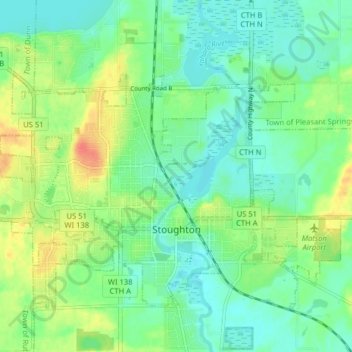
Name: Stoughton topographic map, elevation, terrain.

Location: Stoughton, Dane County, Wisconsin, 53589, United States (42.90332 -89.26032 42.94790 -89.18063)

Average elevation: 269 m

Minimum elevation: 253 m

Maximum elevation: 300 m

Other topographic maps

Click on a map to view its topography, its elevation and its terrain.

Hope

United States > Wisconsin > Dane County

Average elevation: 269 m

Gear up for your next adventure:

🛁Quick-Dry Microfiber Towel - Space-saving towel that dries rapidly on the move
🧴Bear Spray Holster - Quick-access carry for essential Canadian wilderness safety
🥾Mountain Hiking Shoes - Shoes with superior grip for mountainous terrain
🧊Insulated Water Bottle - Keeps drinks cold in summer and prevents freezing in winter
🥾Trekking Poles - Adjustable trekking poles to reduce knee stress and improve stability

As an Amazon Associate, this site earns from qualifying purchases at no extra cost to you.