Geolocate

South Shore Lake Superior Fish and Wildlife Area topographic map

Interactive map

Click on the map to display elevation.

About this map

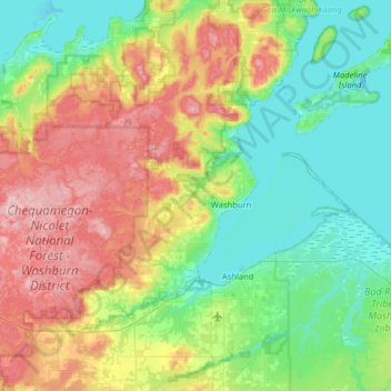
Name: South Shore Lake Superior Fish and Wildlife Area topographic map, elevation, terrain.

Location: South Shore Lake Superior Fish and Wildlife Area, Town of Washburn, Bayfield County, Wisconsin, United States (46.53011 -91.49469 46.83531 -90.85609)

Average elevation: 261 m

Minimum elevation: 176 m

Maximum elevation: 446 m

Other topographic maps

Click on a map to view its topography, its elevation and its terrain.

Red Cliff

United States > Wisconsin > Bayfield County

Red Cliff, Town of Russell, Bayfield County, Wisconsin, 54814, United States

Average elevation: 215 m