
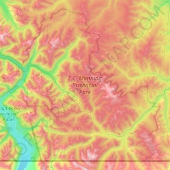
E.C. Manning Provincial Park topographic map
Interactive map
Click on the map to display elevation.
About this map
Name: E.C. Manning Provincial Park topographic map, elevation, terrain.
Average elevation: 1,466 m
Minimum elevation: 476 m
Maximum elevation: 2,514 m
Other topographic maps
Click on a map to view its topography, its elevation and its terrain.
Vancouver
Canada > British Columbia > Metro Vancouver Regional District
Vancouver, Metro Vancouver Regional District, British Columbia, Canada
Average elevation: 34 m
Vernon
Canada > British Columbia > Regional District of North Okanagan
Vernon, Regional District of North Okanagan, British Columbia, Canada
Average elevation: 676 m
Chilliwack
Canada > British Columbia > Fraser Valley Regional District
Chilliwack, Fraser Valley Regional District, British Columbia, Canada
Average elevation: 240 m
Victoria
Canada > British Columbia > Capital Regional District
Victoria, Capital Regional District, British Columbia, Canada
Average elevation: 17 m
New Westminster
Canada > British Columbia > Metro Vancouver Regional District
New Westminster, Metro Vancouver Regional District, British Columbia, Canada
Average elevation: 44 m
Abbotsford
Canada > British Columbia > Fraser Valley Regional District
Abbotsford, Fraser Valley Regional District, British Columbia, Canada
Average elevation: 99 m
Nanaimo
Canada > British Columbia > Regional District of Nanaimo
Nanaimo, Regional District of Nanaimo, British Columbia, Canada
Average elevation: 110 m
Kelowna
Canada > British Columbia > Regional District of Central Okanagan
Kelowna, Regional District of Central Okanagan, British Columbia, Canada
Average elevation: 704 m
Campbell River
Canada > British Columbia > Strathcona Regional District
Campbell River, Strathcona Regional District, British Columbia, Canada
Average elevation: 70 m
Revelstoke
Canada > British Columbia > Columbia-Shuswap Regional District
Revelstoke, Columbia-Shuswap Regional District, British Columbia, Canada
Average elevation: 982 m
Duncan
Canada > British Columbia > Cowichan Valley Regional District
Duncan, Cowichan Valley Regional District, British Columbia, Canada
Average elevation: 26 m
Richmond
Canada > British Columbia > Metro Vancouver Regional District
Richmond, Metro Vancouver Regional District, British Columbia, Canada
Average elevation: 16 m
Vancouver Island
Vancouver Island, British Columbia, Canada
Average elevation: 411 m
Metro Vancouver Regional District
Metro Vancouver Regional District, British Columbia, Canada
Average elevation: 343 m
Penticton
Canada > British Columbia > Regional District of Okanagan-Similkameen
Penticton, Regional District of Okanagan-Similkameen, British Columbia, Canada
Average elevation: 702 m
Comox Valley Regional District
Comox Valley Regional District, British Columbia, Canada
Average elevation: 358 m
Stanley Park
Canada > British Columbia > Metro Vancouver Regional District > Vancouver
Stanley Park, West End, Vancouver, Metro Vancouver Regional District, British Columbia, V6G, Canada
Average elevation: 14 m
Fairmont Hot Springs
Canada > British Columbia > Fairmont Hot Springs
Fairmont Hot Springs, Regional District of East Kootenay, British Columbia, V0B 1L0, Canada
Average elevation: 920 m
Maple Ridge
Canada > British Columbia > Maple Ridge
Maple Ridge, Metro Vancouver Regional District, British Columbia, V2X 6G2, Canada
Average elevation: 193 m
Port Moody
Canada > British Columbia > Metro Vancouver Regional District
Port Moody, Metro Vancouver Regional District, British Columbia, Canada
Average elevation: 189 m
Surrey
Canada > British Columbia > Metro Vancouver Regional District
Surrey, Metro Vancouver Regional District, British Columbia, Canada
Average elevation: 28 m
Nelson
Canada > British Columbia > Regional District of Central Kootenay
Nelson, Regional District of Central Kootenay, British Columbia, Canada
Average elevation: 1,325 m
West Kelowna
Canada > British Columbia > Regional District of Central Okanagan
West Kelowna, Westbank First Nation #9, Regional District of Central Okanagan, British Columbia, Canada
Average elevation: 649 m
Victoria
Canada > British Columbia > Capital Regional District > Victoria
Victoria, Capital Regional District, British Columbia, V8W 1P6, Canada
Average elevation: 47 m
Fraser River
Canada > British Columbia > Chilliwack > Hope > Deroche
Fraser River, Flood Hope Road, Hope, Fraser Valley Regional District, British Columbia, V0X 1L1, Canada
Average elevation: 865 m
T'it'q'et First Nation
Canada > British Columbia > Squamish-Lillooet Regional District > Area B (Cayoosh/Pavilion)
T'it'q'et First Nation, Area B (Cayoosh/Pavilion), Squamish-Lillooet Regional District, British Columbia, Canada
Average elevation: 1,092 m
University Endowment Lands
Canada > British Columbia > Metro Vancouver Regional District
University Endowment Lands, Metro Vancouver Regional District, British Columbia, V6T 1E2, Canada
Average elevation: 58 m
West Vancouver
Canada > British Columbia > Metro Vancouver Regional District
West Vancouver, Metro Vancouver Regional District, British Columbia, Canada
Average elevation: 384 m
Delta
Canada > British Columbia > Metro Vancouver Regional District
Delta, Metro Vancouver Regional District, British Columbia, Canada
Average elevation: 13 m
Courtenay
Canada > British Columbia > Comox Valley Regional District
Courtenay, Comox Valley Regional District, British Columbia, Canada
Average elevation: 47 m
Kamloops
Canada > British Columbia > Thompson-Nicola Regional District
Kamloops, Thompson-Nicola Regional District, British Columbia, Canada
Average elevation: 833 m
North Vancouver
Canada > British Columbia > North Vancouver
North Vancouver, Metro Vancouver Regional District, British Columbia, V7M 1H9, Canada
Average elevation: 258 m
Township of Langley
Canada > British Columbia > Metro Vancouver Regional District
Township of Langley, Metro Vancouver Regional District, British Columbia, Canada
Average elevation: 47 m
Burnaby
Canada > British Columbia > Metro Vancouver Regional District
Burnaby, Metro Vancouver Regional District, British Columbia, Canada
Average elevation: 59 m
Hope
Canada > British Columbia > Fraser Valley Regional District
Hope, Fraser Valley Regional District, British Columbia, Canada
Average elevation: 675 m
Port Alberni
Canada > British Columbia > Alberni-Clayoquot Regional District
Port Alberni, Alberni-Clayoquot Regional District, British Columbia, Canada
Average elevation: 83 m
Parksville
Canada > British Columbia > Regional District of Nanaimo
Parksville, Regional District of Nanaimo, British Columbia, Canada
Average elevation: 38 m
Coquitlam
Canada > British Columbia > Metro Vancouver Regional District
Coquitlam, Metro Vancouver Regional District, British Columbia, Canada
Average elevation: 190 m
Prince George
Canada > British Columbia > Regional District of Fraser-Fort George
Prince George, Regional District of Fraser-Fort George, British Columbia, Canada
Average elevation: 685 m
Kamloops
Canada > British Columbia > Thompson-Nicola Regional District > Kamloops
Kamloops, Thompson-Nicola Regional District, British Columbia, V2C 2E3, Canada
Average elevation: 875 m
Aldergrove
Canada > British Columbia > Metro Vancouver Regional District > Township of Langley
Aldergrove, Township of Langley, Metro Vancouver Regional District, British Columbia, Canada
Average elevation: 107 m
Fraser Valley Regional District
Fraser Valley Regional District, British Columbia, Canada
Average elevation: 1,025 m
Chapman Lake
Canada > British Columbia > Regional District of Okanagan-Similkameen > Area H (Manning Park/Tulameen/Siwash)
Chapman Lake, Area H (Manning Park/Tulameen/Siwash), Regional District of Okanagan-Similkameen, British Columbia, Canada
Average elevation: 1,669 m
North Pender Island
Canada > British Columbia > Capital Regional District > Southern Gulf Islands Electoral Area
North Pender Island, Southern Gulf Islands Electoral Area, Capital Regional District, British Columbia, Canada
Average elevation: 23 m
Oak Bay
Canada > British Columbia > Capital Regional District
Oak Bay, Capital Regional District, British Columbia, Canada
Average elevation: 17 m
Squamish
Canada > British Columbia > Squamish-Lillooet Regional District
Squamish, Squamish-Lillooet Regional District, British Columbia, Canada
Average elevation: 844 m
White Rock
Canada > British Columbia > Metro Vancouver Regional District
White Rock, Metro Vancouver Regional District, British Columbia, Canada
Average elevation: 31 m
Mission
Canada > British Columbia > Fraser Valley Regional District
Mission, Fraser Valley Regional District, British Columbia, Canada
Average elevation: 345 m
Whistler
Canada > British Columbia > Squamish-Lillooet Regional District > Whistler Resort Municipality > Whistler
Whistler, Whistler Resort Municipality, Squamish-Lillooet Regional District, British Columbia, 8E 0X5, Canada
Average elevation: 996 m
Shawnigan Lake
Canada > British Columbia > Cowichan Valley Regional District > Area B (Shawnigan Lake)
Shawnigan Lake, Area B (Shawnigan Lake), Cowichan Valley Regional District, British Columbia, V0R 2W2, Canada
Average elevation: 128 m