
Kabini topographic map
Click on the map to display elevation.
About this map
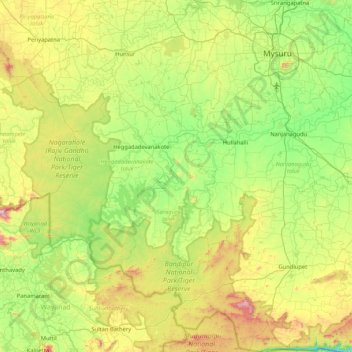
Name: Kabini topographic map, elevation, terrain.
Average elevation: 794 m
Minimum elevation: 469 m
Maximum elevation: 1,558 m
Other topographic maps
Click on a map to view its topography, its elevation and its terrain.
Pavagada
India > Karnataka > Pavagada taluk
Pavagada is located at 14°06′N 77°16′E / 14.1°N 77.27°E / 14.1; 77.27. It has an average elevation of 646 metres (2,119 feet).
Average elevation: 643 m
Chikkaballapura
India > Karnataka > Chikkaballapura taluk
The town of Chikkaballapur is approximately 56 km north of Bengaluru (formerly Bangalore) & Kolar city. Chikkaballapur has a high elevation located in the center of the Nandi Hills region. "Panchagiri" is a common descriptor of Chikkaballapur as it is surrounded by 5 picturesque hills among which Nandi Hills…
Average elevation: 929 m
Ranebennur
India > Karnataka > Ranebennuru taluk
Ranebennuru is at the geographical center of Karnataka. 14°37′N 75°37′E / 14.62°N 75.62°E / 14.62; 75.62. It has an average elevation of 605 metres (1,985 ft). One of Karnataka's most important rivers – the Tungabhadra – flows along the southern border of Ranebennur taluk. Another river,…
Average elevation: 574 m
Arasikere
India > Karnataka > Arasikere taluku
Arsikere is located at 13°18′52″N 76°15′25″E / 13.31444°N 76.25694°E / 13.31444; 76.25694. It has an average elevation of 812 metres (2,664 feet).
Average elevation: 835 m
Nanjanagudu
India > Karnataka > Nanjanagudu
Nanjangud is located at 15°07′N 76°41′E / 15.12°N 76.68°E / 15.12; 76.68. It has an average elevation of 657 metres (2155 ft). The taluk borders Mysore taluk of Mysore district to the north, T Narsipur taluk of Mysore district to the east, H D Kote taluk of Mysore district to the west and…
Average elevation: 667 m
Holalkere
India > Karnataka > Holalkere taluk
Holalkere is located at 14°02′N 76°11′E / 14.03°N 76.18°E / 14.03; 76.18. It has an average elevation of 711 metres (2332 feet).
Average elevation: 715 m
Bagalkote
India > Karnataka > Bagalakote taluk
Bagalkote, is a city in the state of Karnataka, India, which is also the headquarters of Bagalkot district. It is situated on branch of River Ghataprabha, The population of the urban agglomeration was 111,933 according to the provisional results of 2011 national census of India, the city is spread over an area…
Average elevation: 556 m
Madikeri
India > Karnataka > Madikeri taluku
Madikeri features a tropical highland climate as it has an elevation of 1,170 m (3,840 ft). Madikeri is located at 12°25′N 75°44′E / 12.42°N 75.73°E / 12.42; 75.73. Madikeri lies in the Western Ghats and is a popular hill station. Nearest major cities are Hassan (110 kilometres (68 mi)) to the…
Average elevation: 1,054 m
Kolar
India > Karnataka > Kolar taluk
Kolar is located at 13°08′N 78°08′E / 13.13°N 78.13°E / 13.13; 78.13. with an average elevation of 849 metres (2,785 ft).
Average elevation: 847 m
Bengaluru
India > Karnataka > Bangalore North
Bangalore (/ˈbæŋɡəlɔːr, ˌbæŋɡəˈlɔːr/ BANG-gə-lor, -LOR), officially Bengaluru (Kannada pronunciation: [ˈbeŋgɐɭuːɾu] ), is the capital and largest city of the southern Indian state of Karnataka. It has a population of more than 8 million and a metropolitan population of around 15…
Average elevation: 879 m
Chitradurga
India > Karnataka > Chitradurga taluku
Chitradurga is located at 14°14′N 76°24′E / 14.23°N 76.4°E / 14.23; 76.4. It has an average elevation of 732 metres (2401 ft).
Average elevation: 722 m
Bidar
India > Karnataka > Bidar taluku
Bidar is located at 17°54′N 77°30′E / 17.9°N 77.5°E / 17.9; 77.5, lies at a central position in Deccan, a plateau at an elevation of 2300 ft from the sea level. It has common boundaries with Maharashtra and Telangana which is, with the districts of Nizamabad and Medak in Telangana on the East…
Average elevation: 593 m
Sirsi
India > Karnataka > Shirasi Taluk
Sirsi is located at 14°37′N 74°51′E / 14.62°N 74.85°E / 14.62; 74.85 (Grid Square MK74). It has an elevation ranging between 1860 feet to 2600 feet above sea level, and is situated in the heart of the Western Ghats. Sirsi is about 399 kilometres (248 mi) from Bangalore, 144 km from Shimoga, 72…
Average elevation: 556 m
Navalagunda
India > Karnataka > Navalagunda taluku
Navalgund is located at 15°34′N 75°22′E / 15.57°N 75.37°E / 15.57; 75.37. It has an average elevation of 578 metres (1896 feet). It is situated 35 km from Hubli and is famous as the birth place of 'Jamkhanas', the floor covering woven using cotton ropes, a kind of flat & thin carpet. It is…
Average elevation: 579 m
Udupi
India > Karnataka > Udupi taluku
Udupi has an elevation of 27 m (89 ft) above mean sea level. The climate in Udupi is hot in summers and pleasant in winter. During summers (from March to May) the temperature reaches up to 38 °C (100 °F) and in winters (from December to February) it is usually between 32 and 20 °C (90 and 68 °F). As it is…
Average elevation: 17 m
Hosanagara
India > Karnataka > Hosanagara taluk
Hosanagar is located at 13°55′N 75°04′E / 13.92°N 75.07°E / 13.92; 75.07. It has an average elevation of 585 metres (1919 feet).
Average elevation: 584 m
Kongara Nanjayyana Hundi
India > Karnataka > Mysuru taluk > Kongara Nanjayyana Hundi
Average elevation: 694 m
Moodabidri
India > Karnataka > Moodabidri taluk
Its average elevation is 147 metres (482 ft).
Average elevation: 111 m