Geolocate

Uppoor topographic map

Click on the map to display elevation.

About this map

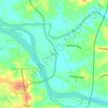
Name: Uppoor topographic map, elevation, terrain.

Location: Uppoor, Udupi taluku, Udupi district, Karnataka, 576105, India (13.37897 74.72930 13.41897 74.76930)

Average elevation: 14 m

Minimum elevation: 0 m

Maximum elevation: 39 m

Gear up for your next adventure:

🧭Orienteering Kit - Tools for map reading and navigation in the wild
🛶Waterproof Dry Bags - Keep electronics and clothes dry during river crossings
🧭GPS Handheld Device - Reliable GPS navigation for outdoor adventures
🧰Survival Kit - Essential gear for emergencies in the wilderness
🧦Hiking Liner Socks - Thin base layer to prevent friction and blisters

As an Amazon Associate, this site earns from qualifying purchases at no extra cost to you.