Geolocate

Byrapura topographic map

Click on the map to display elevation.

About this map

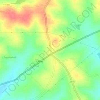
Name: Byrapura topographic map, elevation, terrain.

Location: Byrapura, Aluru taluk, Hassan district, Karnataka, India (12.95780 75.98214 12.96431 75.98773)

Average elevation: 949 m

Minimum elevation: 915 m

Maximum elevation: 984 m

Gear up for your next adventure:

💧Hydration Bladder - Hands-free hydration solution for long treks
🥾Lightweight Hiking Shoes - Comfortable shoes for day hikes
🎒Hiking Daypack - Lightweight and durable backpacks for day trips and excursions
🥾Trail Running Shoes - Lightweight and durable shoes for trail running
🧴Bear Spray Holster - Quick-access carry for essential Canadian wilderness safety

As an Amazon Associate, this site earns from qualifying purchases at no extra cost to you.