
Thank you for supporting this site ❤️
Make a donation
Make a donation
Gear up for your next adventure:
As an Amazon Associate, this site earns from qualifying purchases at no extra cost to you.
Kanuru topographic map
Click on the map to display elevation.
Thank you for supporting this site ❤️
Make a donation
Make a donation
Gear up for your next adventure:
As an Amazon Associate, this site earns from qualifying purchases at no extra cost to you.
About this map
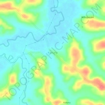
Name: Kanuru topographic map, elevation, terrain.
Location: Kanuru, Ponnampete taluk, Kodagu, Karnataka, 571216, India (12.06835 76.00161 12.10835 76.04161)
Average elevation: 826 m
Minimum elevation: 806 m
Maximum elevation: 867 m
Thank you for supporting this site ❤️
Make a donation
Make a donation
Gear up for your next adventure:
As an Amazon Associate, this site earns from qualifying purchases at no extra cost to you.