
Make a donation
Gear up for your next adventure:
As an Amazon Associate, this site earns from qualifying purchases at no extra cost to you.
Vijayapura topographic map
Click on the map to display elevation.
Make a donation
Gear up for your next adventure:
As an Amazon Associate, this site earns from qualifying purchases at no extra cost to you.
About this map
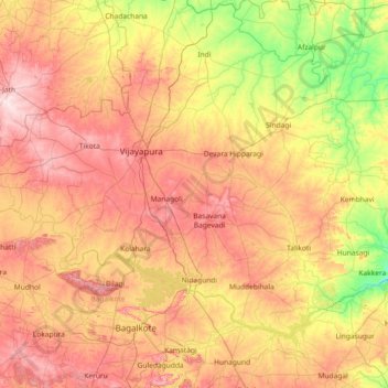
Name: Vijayapura topographic map, elevation, terrain.
Location: Vijayapura, Karnataka, India (15.96667 75.21667 17.36667 76.61667)
Average elevation: 532 m
Minimum elevation: 360 m
Maximum elevation: 759 m
Make a donation
Gear up for your next adventure:
As an Amazon Associate, this site earns from qualifying purchases at no extra cost to you.
Other topographic maps
Click on a map to view its topography, its elevation and its terrain.
Bidar
Physiographically, the district can be divided into two regions, the northern low lands and southern high lands. The southern high lands are popularly known as Bidar plateau, which is made up of laterite. The ground altitudes are varying from 420 to 684 m (1,378 to 2,244 ft) above sea level. Bidar plateau has…
Average elevation: 576 m
Make a donation
Gear up for your next adventure:
As an Amazon Associate, this site earns from qualifying purchases at no extra cost to you.
Make a donation
Gear up for your next adventure:
As an Amazon Associate, this site earns from qualifying purchases at no extra cost to you.