Geolocate

Anekal topographic map

Click on the map to display elevation.

Anekal

Anekal is located at 12°42′N 77°42′E / 12.7°N 77.7°E / 12.7; 77.7. It has an average elevation of 915 metres (3001 feet).

Wikipedia (CC-BY-SA 3.0)

About this map

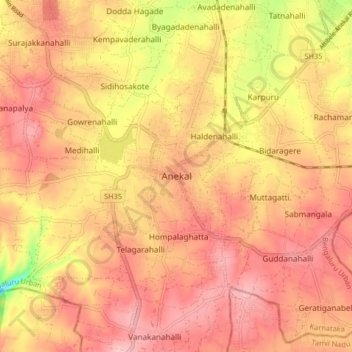
Name: Anekal topographic map, elevation, terrain.

Location: Anekal, Bengaluru Urban, Karnataka, 562106, India (12.66864 77.65940 12.74864 77.73940)

Average elevation: 922 m

Minimum elevation: 822 m

Maximum elevation: 969 m

Other topographic maps

Click on a map to view its topography, its elevation and its terrain.

Gattahalli

India > Karnataka > Anekal

Average elevation: 905 m

Gear up for your next adventure:

🔋Emergency Crank Radio - Weather alerts and power without needing batteries
🩹Moleskin Blister Pads - Direct protection for painful foot pressure points
🔭Outdoor Binoculars - Lightweight binoculars for birdwatching and hiking
💡LED Camping Lantern - Illuminate your campsite with long-lasting lanterns
🥾Waterproof Hiking Boots - Essential footwear for rugged terrain and wet Canadian trails

As an Amazon Associate, this site earns from qualifying purchases at no extra cost to you.