Geolocate

Chitradurga topographic map

Click on the map to display elevation.

Chitradurga

Chitradurga is located at 14°14′N 76°24′E / 14.23°N 76.4°E / 14.23; 76.4. It has an average elevation of 732 metres (2401 ft).

Wikipedia (CC-BY-SA 3.0)

About this map

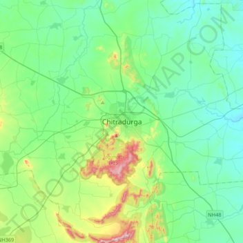
Name: Chitradurga topographic map, elevation, terrain.

Location: Chitradurga, Chitradurga taluku, Chitradurga District, Karnataka, 577500, India (14.06664 76.24051 14.38664 76.56051)

Average elevation: 722 m

Minimum elevation: 607 m

Maximum elevation: 1,151 m

Gear up for your next adventure:

🧥Softshell Hiking Jacket - The perfect balance of wind protection and breathability
🪜Heavy Duty Carabiners - Multi-use clips for securing gear to your backpack
🕶️Polarized Sunglasses - Protect your eyes with durable polarized lenses
🔦LED Headlamp - Hands-free lighting for early morning starts or late finishes
Lightweight Backpacking Tent - Compact tent for efficient hiking trips

As an Amazon Associate, this site earns from qualifying purchases at no extra cost to you.