
Golden Valley County topographic map
Interactive map
Click on the map to display elevation.
About this map
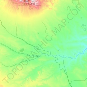
Name: Golden Valley County topographic map, elevation, terrain.
Location: Golden Valley County, Montana, United States (46.04445 -109.65426 46.75153 -108.77776)
Average elevation: 1,276 m
Minimum elevation: 995 m
Maximum elevation: 2,615 m
Other topographic maps
Click on a map to view its topography, its elevation and its terrain.
Bozeman
United States > Montana > Gallatin County
Bozeman, Gallatin County, Montana, United States
Average elevation: 1,495 m
Estes Lake
United States > Montana > Lake County
Estes Lake, Lake County, Montana, United States
Average elevation: 1,068 m
Darby
United States > Montana > Ravalli County
Darby, Ravalli County, Montana, United States
Average elevation: 1,210 m
Lost Horse Mountain
United States > Montana > Powell County
Lost Horse Mountain, Powell County, Montana, United States
Average elevation: 1,795 m
Bancroft Pond Nature Area
United States > Montana > Missoula County > Missoula
Bancroft Pond Nature Area, Lewis & Clark, Missoula, Missoula County, Montana, United States
Average elevation: 1,005 m
Whitefish
United States > Montana > Flathead County
Whitefish, Flathead County, Montana, 59937, United States
Average elevation: 1,075 m
Gold Butte
United States > Montana > Rosebud County
Gold Butte, Rosebud County, Montana, United States
Average elevation: 899 m
Missoula
United States > Montana > Missoula County
Missoula, Missoula County, Montana, United States
Average elevation: 1,173 m
Thompson Falls
United States > Montana > Sanders County
Thompson Falls, Sanders County, Montana, 59873, United States
Average elevation: 782 m
Big Sky Mobile Home Park
United States > Montana > Ravalli County
Big Sky Mobile Home Park, Ravalli County, Montana, 59840, United States
Average elevation: 1,116 m
Crow Agency
United States > Montana > Big Horn County
Crow Agency, Big Horn County, Montana, 59022, United States
Average elevation: 959 m
Morgan
United States > Montana > Phillips County
Morgan, Phillips County, Montana, United States
Average elevation: 854 m
Toad Lake
United States > Montana > Glacier County
Toad Lake, Glacier County, Montana, United States
Average elevation: 1,486 m
Mount Wam
United States > Montana > Lincoln County
Mount Wam, Lincoln County, Montana, United States
Average elevation: 1,944 m
Miles City
United States > Montana > Custer County
Miles City, Custer County, Montana, United States
Average elevation: 724 m
St. Marie
United States > Montana > Valley County
St. Marie, Valley County, Montana, 59231, United States
Average elevation: 811 m
Polaris
United States > Montana > Beaverhead County
Polaris, Beaverhead County, Montana, United States
Average elevation: 2,016 m
Jackson
United States > Montana > Beaverhead County
Jackson, Beaverhead County, Montana, 59736, United States
Average elevation: 1,995 m
Belgrade
United States > Montana > Gallatin County
Belgrade, Gallatin County, Montana, 59714, United States
Average elevation: 1,355 m
Flathead Lake
United States > Montana > Lake County
Flathead Lake, Lake County, Montana, United States
Average elevation: 1,168 m
Garfield County
Garfield County, Montana, United States
Average elevation: 827 m
Roosevelt County
Roosevelt County, Montana, United States
Average elevation: 703 m
Monida
United States > Montana > Beaverhead County
Monida, Beaverhead County, Montana, United States
Average elevation: 2,111 m
Sky Pilot
United States > Montana > Ravalli County
Sky Pilot, Ravalli County, Montana, United States
Average elevation: 2,281 m
Glacier National Park
Glacier National Park, Montana, 59916, United States
Average elevation: 1,594 m
Chrome Island
United States > Montana > Wibaux County
Chrome Island, Wibaux County, Montana, United States
Average elevation: 730 m
Red Lodge
United States > Montana > Carbon County > Red Lodge
Red Lodge, Carbon County, Montana, 59068, United States
Average elevation: 1,720 m
Lightning Lake
United States > Montana > Gallatin County
Lightning Lake, Gallatin County, Montana, United States
Average elevation: 2,690 m
Larch Hill
United States > Montana > Flathead County
Larch Hill, Flathead County, Montana, United States
Average elevation: 2,245 m
Silver Bow
United States > Montana > Silver Bow
Silver Bow, Montana, United States
Average elevation: 1,924 m
Big Sky
United States > Montana > Gallatin County
Big Sky, Gallatin County, Montana, United States
Average elevation: 2,435 m
Bozeman
United States > Montana > Gallatin County > Bozeman
Bozeman, Gallatin County, Montana, 59715, United States
Average elevation: 1,679 m
Dillon
United States > Montana > Beaverhead County
Dillon, Beaverhead County, Montana, United States
Average elevation: 1,562 m
Lincoln County
Lincoln County, Montana, United States
Average elevation: 1,283 m
Woods Bay
United States > Montana > Lake County > Orchard Hills Mobile Home Park
Woods Bay, Orchard Hills Mobile Home Park, Lake County, Montana, United States
Average elevation: 944 m
Sunrise Trailer Court
United States > Montana > Pondera County > Conrad > Sunrise Trailer Court
Sunrise Trailer Court, Conrad, Pondera County, Montana, United States
Average elevation: 1,071 m
Huston
United States > Montana > Missoula County
Huston, Missoula County, Montana, United States
Average elevation: 2,321 m
Whitehall
United States > Montana > Jefferson County > Whitehall
Whitehall, Jefferson County, Montana, United States
Average elevation: 1,336 m
Sidney
United States > Montana > Sidney
Sidney, Richland County, Montana, 59270, United States
Average elevation: 593 m
Waterton River
United States > Montana > Glacier County
Waterton River, Glacier County, Montana, United States
Average elevation: 1,700 m
Springhill
United States > Montana > Gallatin County > Springhill
Springhill, Gallatin County, Montana, United States
Average elevation: 1,491 m
Old Woman Lake
Old Woman Lake, Blaine County, Montana, United States
Average elevation: 787 m
Pony
United States > Montana > Madison County
Pony, Madison County, Montana, 59747, United States
Average elevation: 1,766 m
Poplar River
United States > Montana > Roosevelt County
Poplar River, Roosevelt County, Montana, 59255, United States
Average elevation: 622 m
Harrison Mill
United States > Montana > Harrison Mill
Harrison Mill, Madison County, Montana, 59735, United States
Average elevation: 1,487 m
Lewis and Clark County
Lewis and Clark County, Montana, United States
Average elevation: 1,554 m
Jefferson County
Jefferson County, Montana, United States
Average elevation: 1,750 m
Wheatland County
Wheatland County, Montana, United States
Average elevation: 1,519 m
Yellowstone County
Yellowstone County, Montana, United States
Average elevation: 1,067 m