
Make a donation
Gear up for your next adventure:
As an Amazon Associate, this site earns from qualifying purchases at no extra cost to you.
Sidney topographic map
Click on the map to display elevation.
Make a donation
Gear up for your next adventure:
As an Amazon Associate, this site earns from qualifying purchases at no extra cost to you.
Sidney
Sidney is located in the northeastern part of the state at 47°43′00″N 104°09′23″W / 47.71667°N 104.15639°W / 47.71667; -104.15639 (47.7166836, -104.1563253), at an altitude of 1,942 feet (592 m).
Make a donation
Gear up for your next adventure:
As an Amazon Associate, this site earns from qualifying purchases at no extra cost to you.
About this map
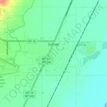
Name: Sidney topographic map, elevation, terrain.
Location: Sidney, Richland County, Montana, 59270, United States (47.69608 -104.20635 47.72959 -104.13905)
Average elevation: 593 m
Minimum elevation: 575 m
Maximum elevation: 656 m
Make a donation
Gear up for your next adventure:
As an Amazon Associate, this site earns from qualifying purchases at no extra cost to you.