
Canary Islands topographic map
Click on the map to display elevation.
Canary Islands
The Canary Islands, especially Tenerife, Gran Canaria, Fuerteventura, and Lanzarote, are a major tourist destination, with over 12 million visitors per year. This is due to their beaches, subtropical climate, and important natural attractions, especially Maspalomas in Gran Canaria and Mount Teide (a World Heritage Site) in Tenerife. Mount Teide is the highest peak in Spain and the 4th tallest volcano in the world, measured from its base on the ocean floor. The islands have warm summers and winters warm enough for the climate to be technically tropical at sea level. The amount of precipitation and the level of maritime moderation vary depending on location and elevation. The archipelago includes green areas as well as desert. The islands' high mountains are ideal for astronomical observation, because they lie above the temperature inversion layer. As a result, the archipelago boasts two professional observatories: the Teide Observatory on Tenerife, and Roque de los Muchachos Observatory on La Palma.
About this map
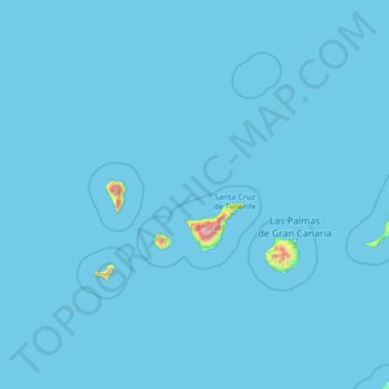
Name: Canary Islands topographic map, elevation, terrain.
Location: Canary Islands, Spain (27.43354 -18.39368 29.91180 -13.10126)
Average elevation: 13 m
Minimum elevation: 0 m
Maximum elevation: 3,432 m
Other topographic maps
Click on a map to view its topography, its elevation and its terrain.
Arrutiegia
Spain > Autonomous Community of the Basque Country > Urola-Kosta > Aia
Average elevation: 223 m
Las Vagas
Spain > Aragon > Cuencas Mineras > Martín del Río > La Rambla de Martín
Average elevation: 1,120 m
El Port de la Selva
Spain > Catalonia > Upper Empordà > el Port de la Selva > El Port de la Selva
Average elevation: 76 m
Donostia / San Sebastián
Spain > Autonomous Community of the Basque Country > Donostialdea > Donostia / San Sebastián
Average elevation: 134 m
Urbanització Cala Llonga
Spain > Balearic Islands > Ibiza > Santa Eulària des Riu
Average elevation: 39 m
Presa de Majarobledo
Spain > Extremadura > Las Hurdes > Casares de las Hurdes
Average elevation: 1,080 m
Murcia
Spain > Region of Murcia > Region of Murcia > Murcia
Murcia is located near the center of a low-lying fertile plain known as the huerta (orchard or vineyard) of Murcia. The Segura River and its right-hand tributary, the Guadalentín, run through the area. The city has an elevation of 43 metres (141 ft) above sea level and its municipality covers approximately…
Average elevation: 169 m
Madrid
Spain > Community of Madrid > Área metropolitana de Madrid y Corredor del Henares > Madrid
Average elevation: 650 m